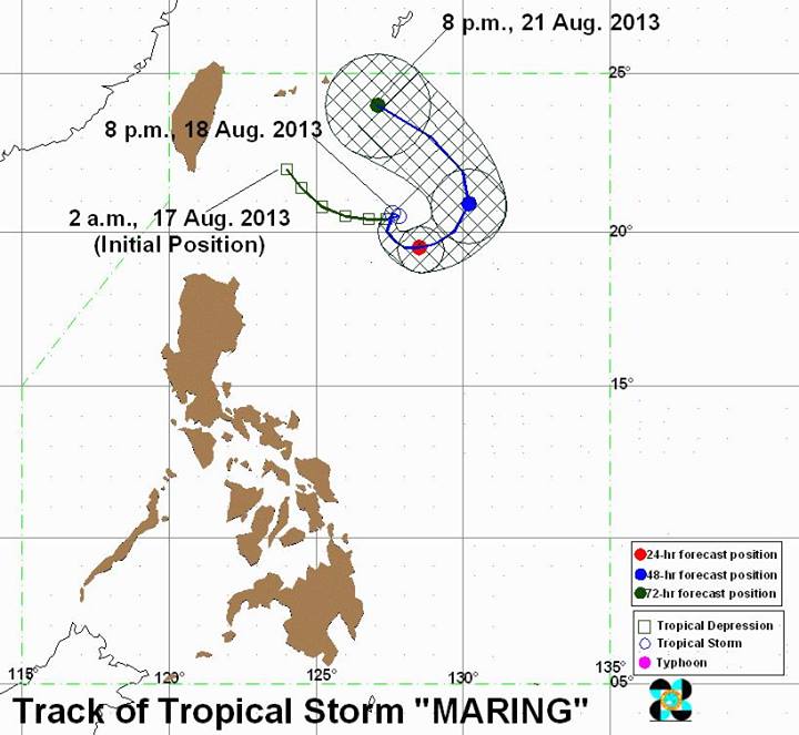
After enhancing the southwest monsoon that has dumped rain over a wide swath of Luzon in the past several days, Tropical Storm Maring (Trami) is moving erratically and may linger inside the Philippine area of responsibility until Thursday.
Large parts of Metro Manila are already flooded, with classes suspended in most areas.
PAGASA forecaster Manny Mendoza said Maring is interacting with another weather system outside the Philippine area of responsibility and has repeatedly changed direction.
“Medyo mabagal ito, pabago-bago ang direksyon ng bagyong ito. Dati southeast, tapos east, ngayon north-northeast (Maring is moving very slowly, and keeps changing direction. It was moving southeast, then east, then north-northeast),” Mendoza said in an interview on dzBB radio.
When asked when Maring will exit the Philippine area of responsibility, Mendoza said their models show it may do so on August 22, Thursday.
However, he said there is also a chance Maring may exit the PAR on Friday.

Tropical Storm Maring seemed to make a U-turn over the Pacific Ocean section northeast of the Philippines and east of Taiwan.
Flash floods, landslides
PAGASA said that as of 4 a.m., Maring was estimated at 550 km east of Itbayat, Batanes, with maximum winds of 75 kph near the center and gustiness of up to 90 kph.
It is forecast to move northeast at 7 kph.
Also, PAGASA said the southwest monsoon is affecting much of the country.
“Metro Manila, Ilocos Region, CALABARZON and the provinces of Benguet, Zambales, Bataan, Mindoro, Marinduque, Romblon and Bicol region will experience monsoon rains which may trigger flashfloods and landslides,” it said in its 5 a.m. bulletin.
PAGASA said Western Visayas, Zamboanga Peninsula and the rest of Luzon will have “cloudy skies with light to moderate rainshowers and thunderstorms.”
The rest of the country will be partly cloudy to cloudy with isolated rainshowers or thunderstorms.
Waterworld
Several parts of Metro Manila became a waterworld early Monday morning, following heavy rain since Sunday night.
As of 5 a.m., parts of Manila, Quezon City, Makati City and southern Metro Manila remained flooded, with the Buendia off-ramp from the Skyway closed to traffic.
Earlier, it had noted floods near Raya Garden, Ireneville and Water Fun.
These included parts of Barangay Palanan, where floodwaters were 12 inches high and rendered the streets “not passable to light vehicles”.
At Barangay Pio del Pilar, P. Medina, Balderama, M. Reyes, Cojuangco, Dela Rosa, Pasong Tamo, Pasay Road, along Gil Puyat from Batangas to South Superhighway, along Gil Puyat from Medina to Pasong Tamo, Javier M. Antonio and McKinley to J. Victor had floods 24 to 36 inches high and were not passable.
In Valenzuela City, flooded areas included:
– In front of PLV: 2 to 3 inches
– V. Reales block 6: 3 to 6 inches
– Dalandanan, Good Year: 2 to 3 inches
– Coloong 2 Road: 2 to 3 inches
– MH del Pilar, Tiwala cor. Coloong 2: 4 to 5 inches
– A. Fernando, Marulas: 3 to 4 inches
In Taguig City, flooding was reported along Palar, Pinagsama, Diego Silang, Waterfun, Hagonoy, Bagumbayan Laura Drive, and Western Bicutan Katipunan.
Meanwhile, dzBB radio reported knee-deep floods at the South Luzon Expressway Southwoods exit, allowing only trucks and buses to pass
Earlier, dzBB reported parts of Manila and Quezon City were still flooded as of early Monday, in the wake of heavy rain since Sunday night. — ELR/HS, GMA News
![]()