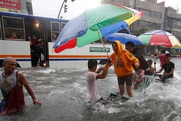
Standstill in Metro Manila as flood affects millions. A woman on an improvised cart reacts as a passenger bus passes along a flooded street in Manila at the height of Storm Mario on Friday, September 19. Thousands of residents in low-lying areas were moved to higher ground, officials said, as flood waters rose quickly after the equivalent of half a month’s usual rain fell in six hours. Reuters/Erik De Castro
(Updated 12:13 p.m.) The National Disaster Risk Reduction and Management Council before noon Saturday clarified the official death toll from Tropical Storm Mario was five and not seven.
NDRRMC executive director Alexander Pama apologized for what he said was a lapse on the agency’s part, radio dzBB’s Rowena Salvacion reported.
But it was not immediately clear who among the fatalities identified in NDRRMC’s 8 a.m. update did not belong on the official list, which also indicated one is still missing.
Also, dzBB said NDRRMC’s corrected report indicated seven (not six) were injured in Mario’s wake.
Among those reported killed earlier were Althea Gaviola, 2; Erlinda Centeno, 69; Tomas Barol, 31; and Javier Jevania Mateo, 1.
Still missing is Ernesto Guevarra, 55.
In its 8 a.m. update, the NDRRMC said 118,839 families or 530,438 people were affected in Ilocos, Central and Southern Luzon, Central Visayas, Cordillera and Metro Manila.
Of these, 23,581 families or 93,062 people are in 181 evacuation centers.
As of 5 a.m. Saturday, some 300 areas in Ilocos, Central and Southern Luzon, Metro Manila and Bicol remained flooded.
Some 87 roads and five bridges are not passable in Cagayan Valley, Central and Southern Luzon, Bicol, Western and Eastern Visayas, and Metro Manila.
Mario intensifies
Mario intensified slightly as it moved toward southern Taiwan before noon Saturday, even as storm signals were still raised in seven areas, PAGASA said.
In its 11 a.m. advisory, it also said Mario is expected to exit the Philippine Area of Responsibility by Sunday evening.
As of 10 a.m., it said Mario was estimated at 143 km north-northwest of Laoag City, with maximum winds of 105 kph near the center and gustiness of up to 135 kph.
Mario is projected to move north-northeast at 15 kph and will be at 244 km north-northwest of Itbayat, Batanes Sunday morning.
By Monday morning, it ie expcted to be at 676 km north-northeast of Itbayat, Batanes or outside the PAR.
Storm signals
Under Storm Signal No. 2 are:
Calayan and Babuyan Islands
Batanes Islands
Apayao
Ilocos Norte
Under Storm Signal No. 1 are:
Cagayan
Kalinga
Abra
Ilocos Sur
PAGASA said Mario may bring rainfall of 7 to 20 mm per hour (moderate to intense) within its 350-km diameter.
It and the Southwest Monsoon will bring moderate to strong winds over Zambales, Bataan and the rest of Northern Luzon, which may have moderate to occasionally heavy rain and thunderstorms which may trigger flash floods and landslides.
Meanwhile, it said Metro Manila, Mimaropa, Calabarzon, and the rest of Central Luzon will have occasional rain.
Also, PAGASA reminded fisherfolk and those with small seacraft not to venture out over the seaboards of Luzon. — Joel Locsin /LBG/ELR, GMA News
![]()