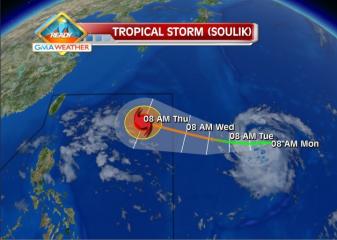
Tropical Storm Soulik forecast track as of 8Jul2013. The Weather Central forecast track for Soulik as of 8am Monday shows that the tropical storm may enter the northeastern corner of the Philippine Area of Responsibility by Wednesday. GMA News
As Typhoon Soulik continued to approach the Philippines Wednesday morning, officials of the Office of Civil Defense in seven regions, including Metro Manila, were instructed to adopt the needed precautions.
The National Disaster Risk Reduction and Management Council had the OCD prepare for the possibility of heavy rain from Soulik, which would be codenamed “Huaning” once it enters the Philippine area of responsibility (PAR).
OCD regional units placed under alert included Metro Manila, Cordillera, Ilocos, Cagayan Valley, Central Luzon, Calabarzon and Mimaropa, radio dzBB reported.
PAGASA earlier said Soulik had intensified into a typhoon and continues to gain strength while approaching Northern Luzon, and may enhance the southwest monsoon.
Meanwhile, the Philippine Coast Guard placed its units in Northern Luzon on alert, radio dzBB’s Carlo Mateo reported.
Coast Guard spokesman Lt. Cmdr. Armand Balilo said the units in Northern Luzon are to go around coastal areas and dissuade fishermen from going out to sea at this time.
PAGASA said Soulik is expected to enter the Philippine area of responsibility as early as 10 a.m. Wednesday. — LBG, GMA News
![]()