Oct 102013
 

Tropical Storm Santi satellite image as of 6:00 p.m., October 10

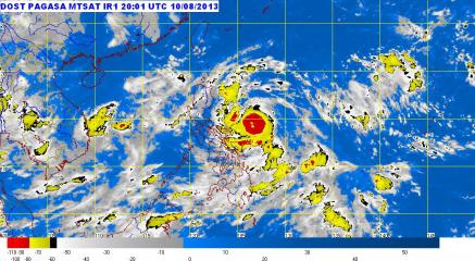
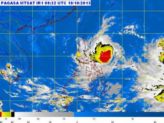
Tropical Storm Santi satellite image as of 6:00 p.m., October 10. At 4:00 PM today, the center of Tropical Storm Santi was estimated at 490 km east of Baler, Aurora (15.6ºN, 126.6ºE) with maximum winds of 95 kph near the center and gustiness of up to 120 kph. It is forecast to move west at 15 kph. PAGASA

The National Disaster Risk Reduction and Management Council went on blue alert Thursday evening for the possible effects of Tropical Storm Santi (Nari).

In its 6 p.m. update, the NDRRMC said blue alert went into effect at noon, meaning at least half its personnel should be ready to respond to contingencies at any time.

Also, it said it will continuously monitor and disseminate weather bulletins and weather forecasts to disaster management councils at the local level.

For its part, the Coast Guard advised watercraft plying Catanduanes routes to suspend their operations, even as its units in Catanduanes and Albay are on heightened alert.

The Department of Social Welfare and Development prepositioned P104.59 million in emergency relief resources.

Death toll from ITCZ rises to 13

Meanwhile, the NDRRMC said the death toll from the heavy rain from the inter-tropical convergence zone rose to 13 Thursday.

In its Thursday update, the NDRRMC said the latest fatalities included Ruel Patrociño, 17, of Tumaga in Zamboanga City; and Rose Flores, 38, of Mangusu Vitali in Zamboanga.

Patrociño died from drowning while Flores was electrocuted, it said.

The NDRRMC also said the ITCZ rain had affected 31,223 families or 138,195 people in 150 villages in 16 towns and nine cities in 10 provinces.

Of these, 5,912 families or 26,828 people are in 46 evacuation centers. — BM, GMA News

Sep 082013
 
PAGASA tracking LPA near Northern Samar

State weather forecasters are now tracking a low-pressure area—a potential cyclone—off Northern Samar in Eastern Visayas. PAGASA, in its 5 p.m. bulletin, said the LPA was estimated in the vicinity of Catarman, Northern Samar as of 4 p.m. It said the LPA was embedded along the inter-tropical convergence zone across Palawan, Visayas and Mindanao and may trigger flash floods and landslides in parts of Southern Luzon. Should the LPA intensify into a cyclone, it will be codenamed Odette. Flash floods, landslides “Calabarzon and the provinces of Mindoro and Marinduque will experience cloudy skies with moderate to occasionally heavy rains and thunderstorms which may trigger flash floods and landslides,” PAGASA said. It added Metro Manila and the rest of the country will have “cloudy skies with light to moderate rainshowers and thunderstorms.” Also, PAGASA’s extended weather outlook expected most major cities will be cloudy with rain showers or thunderstorms on Monday. Only Metro Davao and Zamboanga, Tuguegarao and Laoag Cities will be partly cloudy to cloudy with isolated rain showers or thunderstorms, it added. Monday outlook Meanwhile, PAGASA said moderate to occasionally strong winds from the northeast will prevail over extreme Northern Luzon and its coastal waters will be moderate to occasionally rough. Light to moderate winds coming from the northeast to north will prevail over the rest of Luzon and from the southwest to south over the rest of the country with slight to moderate seas. — BM, GMA News

Sep 052013
 
Naming cyclones after corrupt pols may violate PAGASA rules — weather forecaster

A proposal to name cyclones after corrupt government officials may have little chance of materializing as it could violate the state weather bureau’s rules, a senior weather forecaster said Thursday. PAGASA forecaster Buddy Javier said that while it is “possible” to name a cyclone after a corrupt politicians, one of PAGASA’s rules is that a cyclone’s name must not have “negative or offensive” connotations. “Bawal ang negative o offensive meanings (We cannot name a cyclone based on negative or offensive meanings),” Javier said in an interview on dzBB radio, referring to the rules established in 1999 in naming cyclones. When asked if cyclones can be named after corrupt politicians, he said, “pwede siguro pero paguusapan yan. Matagal na paguusap yan (it’s possible but there would be a long discussion).” An online signature campaign is now circulating to ask PAGASA to name cyclones after corrupt politicians, in the wake of the scandal involving pork barrel funds. “The devastation they cause is so great… Mother Nature can’t even compete with them for the destruction of life and property,” said Ismael Tomelden of Marikina, who started the petition. He added the petition aims to be “a constant reminder of how our hard-earned money has been stolen or misspent by corrupt politicians.” Javier said other criteria for naming cyclones include: – the name cannot start with ñ, ng, or x – the name should not have more than nine letters and three syllables – the name can refer to plants, places, or animals Javier Read More …

Aug 202013
 
Cavite rainfall hits record high, as many suffer Ondoy-like flooding

Cavite residents flee flooded homes, take shelter on street. Residents take shelter from the rain after floodwaters displaced them from their homes in Noveleta, Cavite on Monday. Local government rescue units in Cavite, now under state of calamity, appeared woefully unprepared. AFP PHOTO / Jay Directo For many in Cavite, now under a state of calamity, the past two days have been their Ondoy. A large swath of the province has been submerged as torrential rains have fallen since Sunday night. The rainfall has been at record levels in some areas, particularly in Sangley Point, a part of the provincial capital of Cavite City at the peninsular northernmost point of the province. PAGASA maintains a weather station in Sangley Point, long a naval base. During the Habagat deluge in 2012, rainfall at Sangley Point reached 354.2 mm in the 24 hours ending 8 a.m. on August 7, 2012, according to PAGASA weather division head Robert Sawi. In contrast, rainfall at the same location for the same period on August 20, 2013, reached 475.4 mm. This is even more than the average expected rainfall for the entire month, or 457.4 mm. “Ibig sabihin, mas higit sa isang buwan ang naibagsak na ulan sa loob lamang ng isang araw,” explained GMA News’ resident meteorologist, Nathaniel “Mang Tani” Cruz.  The rain intensity at Sangley Point surprised even DOST Secretary Ramon Montejo.  “We were also surprised at the rain intensity in some areas, especially in Sangley, Cavite,” he said. The disaster seems far from Read More …

Aug 192013
 
PAGASA: Tropical Storm Maring intensifies, nearly stationary

‘Erratic’ Maring lingers northeast of Batanes. Tropical Storm Maring seemed to make a U-turn over the Pacific Ocean section northeast of the Philippines and east of Taiwan. PAGASA Tropical Storm Maring (international name Trami) intensified Monday night and remained almost stationary off extreme northern Luzon, state weather forecasters said. PAGASA, in its 11 p.m. advisory, said Tropical Storm Maring was estimated to be 600 km east of Itbayat, Batanes as of 10 p.m. Maring was moving northwards at only 7 kph. By Tuesday evening, it is expected to be 560 km east-northeast of Itbayat, Batanes. By Wednesday evening it is expected to be 470 km northeast of Itbayat, Batanes. On Thursday evening, it is forecast to be 595 km north of Itbayat, Batanes or outside the Philippine area of responsibility. Maring packed maximum winds of 85 kph near the center, with gustiness of up to 100 kph. No public storm signals have been raised. Heavy to intense rainfall Maring may bring rainfall of 10 to 25 mm per hour (heavy to intense) within its 400-km diameter. It will also continue to enhance the southwest monsoon, which will bring moderate to heavy rainshowers and thunderstorms over Luzon, particularly over the western section. The enhanced monsoon has been bringing rain over Metro Manila and nearby provinces since Sunday. Meanwhile, PAGASA advised fishermen, “especially those using small seacraft,” not to venture out over the seaboards of Luzon due to heavy seas, also caused by the enhanced southwest monsoon. — DVM, GMA News

Aug 162013
 
PAGASA: 'Maring' accelerates east-southeast; Luzon dam opens 1 gate

Tropical Depression Maring slightly accelerated as it moved east-southeast Saturday morning, state weather forecasters said. In its 11 a.m. update, PAGASA said Storm Signal No. 1 over Batanes province in Extreme Northern Luzon has been lifted. “Nguni’t inaasahan pa rin ang moderate to heavy na ulan,” PAGASA forecaster Jori Loiz said in an interview on dzBB radio. Moreover, he said Maring will still enhance the southwest monsoon. PAGASA said that as of 10 a.m., Maring was estimated at 270 km northeast of Itbayat town in Batanes. It packed maximum winds of 55 kph near the center and is forecast to move east-southeast at 11 kph. Maring is expected to be 510 km east of Itbayat, Batanes by Sunday morning, and 740 km northeast of Itbayat by Monday morning. By Tuesday morning, it is expected to be at 960 km northeast of Itbayat. PAGASA said Maring may bring rain of 5 to 10 mm per hour (moderate to heavy) within is 300-km diameter. It added the southwest monsoon enhanced by Maring may bring moderate to heavy rain showers and thunderstorms over the western section of Luzon. Meanwhile, PAGASA said Magat Dam in Isabela opened one gate at one meter. It said that as of 11 a.m., Magat’s water level was at 192.16 meters. Its maximum water level is 193 meters. — LBG, GMA News

Aug 132013
 
PAGASA employees finally receive overdue benefits - report

After several long months of waiting, the country’s weather forecasters finally received some of their overdue benefits. Philippine Weathermen Employees Association head Ramon Agustin said the Budget Department had released the funds and the benefits were received Tuesday noon, radio dzBB reported Tuesday night. The benefits the PAGASA personnel received included longevity and hazard pay from January to June. The weathermen had been waiting for their benefits since January. Agustin thanked their supporters and hoped there would be no repeat of a delay. A report from the state-run Philippines News Agency quoted Agustin as saying the benefits range from P20,000 to P100,000, depending on their salary grades. He said a forecaster can receive at least P60,000 in perks for six months. Earlier this month, PAGASA lost another weather specialist Ricky Fabregas, reportedly after he failed to get his long-overdue benefits. A report by dzBB’s Allan Gatus said Fabregas left for the Congo to take a lower-ranking but higher-paying job. The salary in Congo was about five times Fabregas’ salary in PAGASA – nearly P100,000 a month at his new job compared to his P20,000 monthly pay at PAGASA. — DVM, GMA News

Aug 112013
 
Labuyo moves closer to Aurora; 5 areas under Storm Signal 3

Typhoon Labuyo packs 140 to 170 kph winds, Signal No. 3 raised. PAGASA raised Public Storm Warning Signal No. 3 over Catanduanes as Typhoon Labuyo moved closer to Luzon Sunday morning and is expected to make landfall in Aurora on Monday. PAGASA At least five areas were placed under Storm Signal No. 3 as Typhoon Labuyo (Utor) moved closer to Aurora province Sunday morning, state weather forecasters said. PAGASA said Labuyo was estimated at 160 km northeast of Virac, Catanduanes, or 270 km east-northeast of Daet, Camarines Norte as of 10 a.m. In its 11 a.m. advisory, PAGASA said Labuyo packed maximum winds of 150 kph near the center and gustiness of 185 kph. Labuyo was moving west-northwest at 19 kph and is expected to be in the vicinity of Casiguran, Aurora, Monday morning. By Tuesday morning it is expected to be 270 km northwest of Sinait, Ilocos Norte, or in the northwest boundary of the Philippine area of responsibility. Storm signals Under Signal No. 3 are: CatanduanesCamarines provincesNorthern Quezon including Polilio IslandAuroraIsabela Under Signal No. 2 are: AlbaySorsogonRizalrest of QuezonLagunaBulacanNueva EcijaQuirinoNueva VizcayaBenguetIfugaoMountain ProvinceKalingaCagayan Under Signal No. 1 are: Calayan IslandsBabuyan IslandsIlocos NorteIlocos SurApayaoAbraLa UnionPangasinanTarlacZambalesPampangaBataanCaviteBatangasMarinduqueBuriasTicao IslandsMetro ManilaNorthern Samar Rainfall PAGASA said Labuyo may bring rainfall of 7.5 to 25 mm per hour (heavy to intense) within its 600-km diameter. It advised residents in low-lying and mountainous areas under storm signals to be alert against possible flash floods and landslides. Also, it warned residents in coastal areas under signals 2 and Read More …

Aug 102013
 
NDRRMC on red alert for Typhoon Labuyo; Red Cross alerts chapters

Typhoon Labuyo from the east, monsoon and possible LPA to the west. While Typhoon Labuyo comes from the east in the Pacific Ocean with 140 to 170 kph winds, PAGASA said the typhoon may enhance the southwest monsoon. Surface winds forecasts also show that a possible low pressure area may be forming just outside the Philippine Area of Responsibility far out to the west of Palawan. PAGASA The National Disaster Risk Reduction and Management Council was placed on red alert Sunday morning for the possible effects of Typhoon Labuyo (Utor). NDRRMC spokesman Maj. Rey Balido said a red alert was declared at 8 a.m., with all concerned personnel on standby. “Nag-declare tayo ng red alert effective 8 a.m. Ang regions na naapektuhan at maapektuhan sa susunod na araw, on standby na [ang mga tauhan nila],” Balido said in an interview on dzBB radio. He said those particularly on alert include disaster management teams in Ilocos, Cagayan Valley, Central Luzon, and Cordillera. Also, Balido said teams from various government agencies are on alert and ready to respond to contingencies. These include the Department of Social Welfare and Development, Armed Forces of the Philippines and Philippine National Police, he said. Earlier Sunday, PAGASA said Labuyo intensified further and may make landfall over Aurora province on Monday. Catanduanes province was placed under Storm Signal No. 3 while nine areas were under Signal No. 2 and 26 areas including Metro Manila under Storm Signal No. 1. PAGASA forecaster Glaiza Escullar also warned Labuyo is Read More …

Aug 032013
 
LPA nears Cebu; floods, landslides threaten Palawan, Vis-Min

Rain clouds over much of the Visayas, Mindanao and Bicol. “Eastern Visayas, Caraga and Davao region will experience moderate to occasionally heavy rainshowers and thunderstorms which may trigger flashfloods and landslides,” PAGASA said in its 5:00 p.m. weather bulletin Saturday. PAGASA added that “Palawan, Bicol region and the rest of Visayas and Mindanao will have cloudy skies with light to moderate rainshowers and thunderstorms.” PAGASA Residents in parts of Palawan, Visayas and Mindanao were advised before noon Sunday to brace for possible flash floods and landslides as a potential cyclone moved near Cebu. State weather forecasters said the potential cyclone, a low-pressure area, was estimated in the vicinity of Mactan, Cebu as of 8 a.m. In its 11 a.m. advisory, PAGASA said the LPA is embedded along the inter-tropical convergence zone. “These weather systems are expected to bring moderate to occasionally heavy rains and thunderstorms in Palawan, Visayas and regions of Zamboanga Peninsula Northern Mindanao, ARMM and SOCCSKSARGEN which may trigger flash floods and landslides,” it said. “Residents in these areas are advised to take all the necessary precautionary measures,” it added. Earlier, PAGASA forecaster Joey Figuracion said the LPA has a low chance of becoming a cyclone. But if it does, it will be codenamed Kiko. — LBG, GMA News