TS Gorio seen cutting across Luzon, west-northwest at 15kph. PAGASA forecast in its 11:00 p.m. storm bulletin that TS Gorio will move west-northwest at a pace 15 kilometers per hour with top near-center winds of up to 80 kph. By Saturday evening Gorio may be in the Vicinity of Catarman, Northern Samar. The storm is forecast Sunday evening to be at or ner Cabanatuan City and then by Monday evening, the forecast position is 390 km Northwest of Dagupan City. PAGASA
(UPDATED 12:30 p.m.) – After making landfall in Eastern Visayas, Tropical Storm “Gorio” (international codename Rumbia) accelerated slightly as it continued to move northwest and state weather forecasters said 37 areas are now under storm signals.
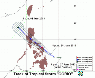
On its 11:00 a.m. advisory, PAGASA said Gorio was estimated at 30 kilometers southeast of Catbalogan, Samar as of 10:00 a.m.
The storm packed maximum winds of 65 kilometers per hour (kph) near the center and gustiness of up to 80 kph.
The center of the storm was noted southeast of Catbalogan, Samar.
On government-run dzRB radio, PAGASA forecaster Joey Figuracion said “Gorio” may be felt in Metro Manila by Sunday.
PAGASA weather models indicate that “Gorio” may cross Zambales and exit the Philippine area of responsibility as early as Monday evening.
The weather agency said “Gorio” was moving northwest at 19 kph and is expected to be in the vicinity of Alabat, Quezon on Sunday morning.
By Monday morning, it is expected to be 170 km east of Dagupan City. By Monday evening it is expected to be 370 km east of Sinait, Ilocos Sur.
Storm signals
At least 11 areas were placed under Storm Signal No. 2 while 26 are under Signal No. 1.
Under Storm Signal Number 2, with winds of 61-100 kph expected in at least 24 hours, are:
- Masbate including Ticao and Burias Islands
- Sorsogon
- Albay
- Catanduanes
- Camarines Sur
- Camarines Norte
- Marinduque
- Quezon including Polilio Island
- Samar provinces
- Biliran
- Leyte
These areas are expected to sustain significant damage, including the uprooting of trees and unroofing of homes made from light materials.
PAGASA added that travel by air or sea are risky.
Under Storm Signal No. 1, with winds of 45-60 kph expected within the next 36 hours, are:
- Romblon
- Oriental Mindoro
- Batangas
- Laguna
- Cavite
- Rizal
- Bataan
- Bulacan
- Zambales
- Tarlac
- La Union
- Benguet
- Ifugao
- Nueva Vizcaya
- Quirino
- Aurora
- Nueva Ecija
- Pampanga
- Pangasinan
- Metro Manila
- Southern Leyte
- Capiz
- Aklan
- Northeastern Iloilo
- Northern Cebu including Camotes Island
- Bantayan Island
Public Storm Warning Signals elsewhere are now lowered, PAGASA said.
“Residents in low-lying and mountainous areas under Signals 2 and 1 are alerted against possible flash floods and landslides,” PAGASA warned.
The weather agency added that those living in coastal areas should keep alert against big waves or storm surges generated by “Gorio.”
PAGASA also said “Gorio: may bring rainfall of 5 to 15 millimeter per hour (moderate to heavy) within its 300-km diameter.
Flooding in Samar
On GMA Network’s “Balitanghali” newscast on Saturday, Dolores Mayor Emilia Villacarillo of Easter Samar told reporter Jun Veneracion that the floods in the area were already at waist level.
Villacarillo noted that if the rains won’t stop, floods may reach dangerous levels.
Residents of flood-prone areas have already been evacuated and there have been no casualties yet, she said.
She also noted that the whole province of Eastern Samar has had no power supply since 9:00 p.m. on Friday and that communication has been difficult with weak mobile phone signals.
Villacarillo said crop damage is expected to be high as the planting season has already begun.
Stranded residents
The report added that the NDRRMC said the Coast Guard in Bicol canceled trips bound for Samar as early as Friday noon.
The NDRRMC also said all ferry terminals in Eastern Samar, Western Samar and Northern Samar were “suspended as of 6:00 a.m. (Friday).”
Of the 2,545 stranded people, 1,120 were in Matnog, 1,271 in Looc, and 154 in Dapdap.
The port of Looc lists the highest number of stranded vehicles in all categories with 44 trucks, 23 light cars and 29 buses.
The total number of stranded vehicles were 102 trucks, 42 vehicles, 53 buses, and five roll-on roll-off vessels.
Domestic flights cancelled
More domestic flights were canceled Saturday noon due to bad weather conditions brought by Tropical Storm Gorio (Rumbia), even as the Philippine Coast Guard warned small vessels in affected areas against going out to sea.
The Department of Transportation and Communications said at least six more flights, including those of PAL Express, Cebu Pacific and South East Asian Airlines, were canceled due to bad weather.
Vessels weighing 1,000 gross tons or below “shall not sail, except to take shelter, when (Signal No.) 1 is hoisted within its point of origin or route or point of destination.”
The movement of vessels above 1,000 gross tons is “left to the discretion and responsibility of the ship owner and master” when Signal No. 1 is hoisted within its point of origin or route or point of destination, it added.
However, vessels of any tonnage “shall not sail, except to take shelter, when (Signal No.) 2 or higher is hoisted within its point of origin or route or point of destination.”
– with a report from Andrei Medina, VVP, GMA News
![]()