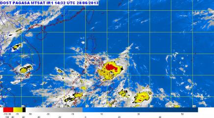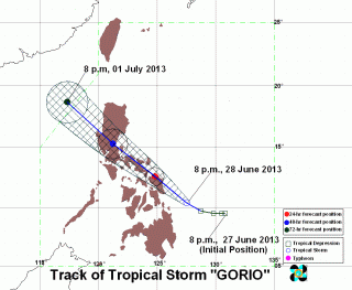
TS Gorio seen cutting across Luzon, west-northwest at 15kph. PAGASA forecast in its 11:00 p.m. storm bulletin that TS Gorio will move west-northwest at a pace 15 kilometers per hour with top near-center winds of up to 80 kph. By Saturday evening Gorio may be in the Vicinity of Catarman, Northern Samar. The storm is forecast Sunday evening to be at or ner Cabanatuan City and then by Monday evening, the forecast position is 390 km Northwest of Dagupan City. PAGASA (UPDATED 12:30 p.m.) – After making landfall in Eastern Visayas, Tropical Storm “Gorio” (international codename Rumbia) accelerated slightly as it continued to move northwest and state weather forecasters said 37 areas are now under storm signals. On its 11:00 a.m. advisory, PAGASA said Gorio was estimated at 30 kilometers southeast of Catbalogan, Samar as of 10:00 a.m. The storm packed maximum winds of 65 kilometers per hour (kph) near the center and gustiness of up to 80 kph. The center of the storm was noted southeast of Catbalogan, Samar. On government-run dzRB radio, PAGASA forecaster Joey Figuracion said “Gorio” may be felt in Metro Manila by Sunday. PAGASA weather models indicate that “Gorio” may cross Zambales and exit the Philippine area of responsibility as early as Monday evening. The weather agency said “Gorio” was moving northwest at 19 kph and is expected to be in the vicinity of Alabat, Quezon on Sunday morning. By Monday morning, it is expected to be 170 km east of Dagupan City. By Monday Read More …