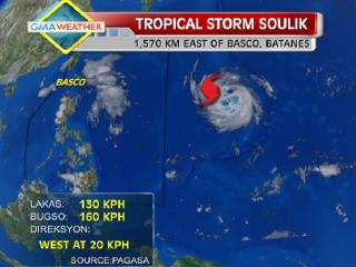
TS Soulik as of 5pm, 9July2013. As of Tuesday afternoon, tropical storm Soulik was located some 1,570km east of Basco, Batanes. It is expected to enter the Philippine Area of Responsibility by Wednesday morning, and will be locally codenamed Huaning. GMA News
Typhoon Huaning (Soulik) maintained its strength as it continued to move west-northwest Wednesday night, state weather forecasters said.
PAGASA, in its 11 p.m. advisory, said Batanes in extreme northern Luzon remained under Storm Signal No. 1.
As of 10 p.m., PAGASA said Huaning was estimated to be 1,030 km east of Itbayat, Batanes, with maximum winds of 175 kph near the center and gustiness of up to 210 kph.
It was moving west-northwest at 20 kph and would be 640 km northeast of Itbayat, Batanes Thursday evening.
By Friday evening, it is expected to be 390 km north-northeast of Itbayat, Batanes. By Saturday evening it is forecast to be 600 km north-northwest of Itbayat, Batanes or outside the Philippine Area of Responsibility.
PAGASA said Huaning may bring rainfall of 10 to 25 mm per hour (heavy to intense) within its 800-km diameter.
PAGASA warned fishermen, especially those using small seacraft, not to venture to the northern and eastern seaboards of Luzon due to big waves generated by Huaning. — DVM, GMA News
![]()