Nov 112013
 

(Updated 9:12 a.m.) Classes were suspended in the entire Bohol province, Bacolod City in Negros Occidental, and Davao City Tuesday due to the threat of bad weather conditions from Tropical Depression Zoraida.

In Bohol, Governor Edgar Chatto ordered the suspension for classes from preschool to high school in private and public schools Tuesday morning, the provincial government said.

“Gov. Chatto suspends classes today in Bohol pre-school/elementary/high school both private and public schools due to TD Zoraida,” it said on its Twitter account 

As of 5 a.m. Tuesday, Bohol was among the areas under Storm Signal No. 1 due to Zoraida.

On Monday, Jagna town in Bohol suspended classes for Tuesday and Wednesday in anticipation of bad weather from Zoraida.

PAGASA earlier said Zoraida may make landfall over the Davao region Tuesday morning.

In Davao City, classes were suspended Tuesday due to the threat of ill weather from Tropical Depression Zoraida, the city government said.

In an advisory, the Davao City government said Mayor Rodrigo Duterte ordered the suspension of classes at all levels, even if Davao City was not under a storm signal.

“PAGASA advisories have stated Davao City will be experiencing rains with gusty winds,” Davao City said in an advisory. 

Meanwhile, state-run Philippine Information Agency said Bacolod City suspended classes in the preschool and elementary levels. Negros Occidental, where Bacolod is located, is also under Signal No. 1 as of 5 a.m.
At least 29 areas in the Visayas and Mindanao were placed under Storm Signal No. 1 early Tuesday, with TD Zoraida expected to make landfall over the Davao region, state weather forecasters said. — with Amanda Fernandez/DVM/RSJ, GMA News

Aug 162013
 
PAGASA: 'Maring' accelerates east-southeast; Luzon dam opens 1 gate

Tropical Depression Maring slightly accelerated as it moved east-southeast Saturday morning, state weather forecasters said. In its 11 a.m. update, PAGASA said Storm Signal No. 1 over Batanes province in Extreme Northern Luzon has been lifted. “Nguni’t inaasahan pa rin ang moderate to heavy na ulan,” PAGASA forecaster Jori Loiz said in an interview on dzBB radio. Moreover, he said Maring will still enhance the southwest monsoon. PAGASA said that as of 10 a.m., Maring was estimated at 270 km northeast of Itbayat town in Batanes. It packed maximum winds of 55 kph near the center and is forecast to move east-southeast at 11 kph. Maring is expected to be 510 km east of Itbayat, Batanes by Sunday morning, and 740 km northeast of Itbayat by Monday morning. By Tuesday morning, it is expected to be at 960 km northeast of Itbayat. PAGASA said Maring may bring rain of 5 to 10 mm per hour (moderate to heavy) within is 300-km diameter. It added the southwest monsoon enhanced by Maring may bring moderate to heavy rain showers and thunderstorms over the western section of Luzon. Meanwhile, PAGASA said Magat Dam in Isabela opened one gate at one meter. It said that as of 11 a.m., Magat’s water level was at 192.16 meters. Its maximum water level is 193 meters. — LBG, GMA News

Jul 112013
 
PAGASA: Huaning weakens slightly, continues moving toward Batanes-Taiwan area

Typhoon Huaning (international name Soulik) weakened slightly even as it continued moving toward the Taiwan-Batanes area Thursday night, state weather forecasters said. PAGASA, in its 11 p.m. advisory, said Huaning was estimated to be 580 km east-northeast of Itbayat, Batanes as of 10 p.m. Huaning packed maximum winds of 175 kph near the center and gustiness of up to 210 kph, and was moving west-northwest at 20 kph. Batanes remained under Storm Signal No. 1. PAGASA projects Huaning may be 370 km north-northeast of Itbayat, Batanes by Friday evening, and 640 km north-northwest of Itbayat, Batanes or outside the Philippine Area of Responsibility by Saturday evening. Meanwhile, PAGASA said Huaning may still bring rainfall of 10 to 46 mm per hour (heavy to torrential) within its 900-km diameter. It warned fishermen, especially those using small seacraft, not to venture out into the northern and eastern seaboards of Luzon due to big waves generated by Huaning. — DVM, GMA News

Jul 102013
 
PAGASA: Huaning maintains strength, west-northwest course

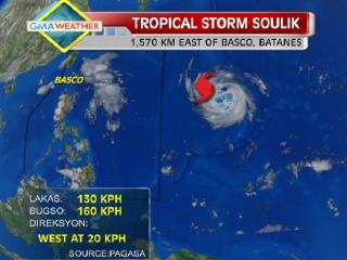
TS Soulik as of 5pm, 9July2013. As of Tuesday afternoon, tropical storm Soulik was located some 1,570km east of Basco, Batanes. It is expected to enter the Philippine Area of Responsibility by Wednesday morning, and will be locally codenamed Huaning. GMA News Typhoon Huaning (Soulik) maintained its strength as it continued to move west-northwest Wednesday night, state weather forecasters said. PAGASA, in its 11 p.m. advisory, said Batanes in extreme northern Luzon remained under Storm Signal No. 1. As of 10 p.m., PAGASA said Huaning was estimated to be 1,030 km east of Itbayat, Batanes, with maximum winds of 175 kph near the center and gustiness of up to 210 kph. It was moving west-northwest at 20 kph and would be 640 km northeast of Itbayat, Batanes Thursday evening. By Friday evening, it is expected to be 390 km north-northeast of Itbayat, Batanes. By Saturday evening it is forecast to be 600 km north-northwest of Itbayat, Batanes or outside the Philippine Area of Responsibility. PAGASA said Huaning may bring rainfall of 10 to 25 mm per hour (heavy to intense) within its 800-km diameter. PAGASA warned fishermen, especially those using small seacraft, not to venture to the northern and eastern seaboards of Luzon due to big waves generated by Huaning. — DVM, GMA News

Jun 292013
 
NCR under storm signal 2; Gorio may pass Metro Manila Sunday morning

Metro Manila and at least 19 other areas were placed under Storm Signal No. 2 Saturday afternoon as Tropical Storm Gorio (Rumbia) accelerated further and was over Sorsogon Bay, state weather forecasters said. PAGASA also said there is a chance Gorio may pass Metro Manila Sunday morning, and exit the Philippine area of responsibility Monday morning. A report by radio dzBB’s Paulo Santos quoted Perez as saying Gorio may pass Metro Manila’s southern part Sunday. But Perez also allayed fears of Gorio causing dams in Luzon to overflow. “Walang [pang dam na] umaabot sa high water level,” he said. PAGASA’s 5 p.m. advisory said that as of 4 p.m., Gorio was estimated at 40 km southeast of Legazpi City, with maximum winds of 65 kph near the center and gustiness of up to 80 kph. It was moving northwest at 24 kph and is expected to be 60 km northwest of Iba, Zambales Sunday afternoon, “after passing Metro Manila in the morning.” By Monday afternoon it is expected to be 560 km northwest of Sinait, Ilocos Sur, and out of the Philippine Area of Responsibility (PAR). The 20 areas under Storm Signal No. 2 include: Masbate including TicaoBurias IslandsSorsogonAlbayCamarines SurCamarines NorteMarinduqueQuezon including Polilio IslandRizalBulacanPampangaTarlacZambalesNueva EcijaPangasinanBatangasLagunaCaviteBataanMetro Manila The 14 areas under Signal No. 1 are: CatanduanesRomblonMindoro Provinces including Lubang IslandLa UnionBenguetNueva VizcayaQuirinoAuroraSamar provincesLeyte provincesBiliranNortheastern IloiloCapizAklan “Residents in low-lying and mountainous areas under signals 2 and 1 are alerted against possible flash floods and landslides. Likewise, those living in coastal areas are Read More …