Cyclone off of PAR as of 5am, July 8. The Japan Meteorological Agency’s forecast track of a cyclone just outside the Philippine Area of Responsibility (PAR) as of 5am (PHT), July 8. At its current rate and direction, PAGASA says it may enter the PAR by Wednesday and may just bring to extreme Northern Luzon. Japan Meteorological Agency
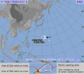
Tropical Storm Soulik intensified further early Tuesday as it continued to approach the Philippines, even as state weather forecasters said the cyclone may enter the Philippine area of responsibility Wednesday and stay until Friday.
But PAGASA forecaster Manny Mendoza said their models show Soulik is not likely to make landfall on any part of the Philippines, even as it will enhance the southwest monsoon.
“Hindi ito magla-landfall sa Pilipinas. Kung papatuloy ito, maaring mag-landfall ito sa Taiwan. Kung west-northwest or northwest ito, sa southeastern China (Our models show it is not likely to make landfall on the Philippines. Our models show it could make landfall on Taiwan. Or if it goes west-northwest or northwest, it could make landfall on Southeastern China),” Mendoza said in an interview on dzBB radio.
Also, he said their models show a possibility of Soulik heading for Korea or even Japan.
So far, Mendoza said their forecast models indicate Soulik is not likely to have any direct effect on the Philippines, but added it will enhance the southwest monsoon and bring rain.
“Hindi masyadong magbibigay ng epekto sa Pilipinas kundi enhancement ng southwest monsoon (We do not expect it to have any direct effect on the Philippines, except enhancing the southwest monsoon),” he said.
Should Soulik enter the Philippine area of responsibility, it will be locally codenamed Huaning.
Mendoza said their models show Soulik will stay in the Philippine area of responsibility until Friday. He said the short stay is due to Soulik’s speed of 20 kph.
As of 4 a.m., PAGASA said Soulik was estimated at 1,780 km east of Basco, Batanes, with maximum sustained winds of 110 kph near the center and gustiness of up to 140 kph.
It said Soulik is forecast to move west at 20 kph.
Tuesday outlook
For Tuesday, PAGASA’s 5 a.m. bulletin said the inter-tropical convergence zone is affecting Palawan and Mindanao.
“Mimaropa, Ilocos region, Zamboanga Peninsula, Soccsksargen and Northern Mindanao will experience cloudy skies with light to moderate rain showers and thunderstorms,” it said.
It added Metro Manila and the rest of the country will be “partly cloudy to cloudy with isolated rain showers or thunderstorms.”
Also, PAGASA said light to moderate winds from the northeast to north will prevail over Luzon and coming from the northwest to southwest over Visayas and Mindanao.
The coastal waters throughout the archipelago will be slight to moderate. — ELR, GMA News
![]()