Satellite Image at 7:30 a.m. Monday, 20 May 2013. | Weather Central
Although there is still no cyclone near the Philippine area of responsibility, residents in parts of northern Luzon and Mindanao may expect rain on Wednesday, state weather forecasters said.
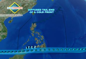
PAGASA forecaster Bernie de Leon said the rain will come from a tail-end of a cold front affecting northern Luzon, while the inter-tropical convergence zone is affecting Mindanao.
“Sa kasalukuyan wala pa tayong namamataang namumuong sama ng panahon sa Philippine area of responsibility. Subali’t nakaaapekto pa rin ang tail end of cold front sa northern Luzon at ITCZ ang nakakaapekto sa southern Mindanao,” de Leon said in an interview on dzBB radio.
In Metro Manila, he said there will be generally good weather but with isolated rain showers and thunderstorms.
PAGASA said Metro Manila may expect temperatures of 26 to 34 degrees Celsius while Tuguegarao City may expect temperatures of 24 to 32 degrees Celsius.
Angeles and Olongapo Cities may expect temperatures of 25 to 32 degrees Celsius, it added.
PAGASA’s 5 a.m. bulletin said: “The regions of Ilocos, Cordillera, Cagayan Valley in [northern Luzon], Davao and Zamboanga Peninsula [in Mindanao] will have cloudy skies with light to moderate rain showers and thunderstorms,” it said.
It added Metro Manila and the rest of the country will be “partly cloudy with isolated rain showers or thunderstorms mostly over the western section.”
Light to moderate winds from the southeast to south will prevail over Luzon and coming from the east to southeast over the rest of the country, it said.
The coastal waters throughout the archipelago will be slight to moderate, PAGASA said. — LBG, GMA News
![]()