Jun 072013
 

Satellite Image at 7 a.m., June 6, 2013

Satellite Image at 7 a.m., June 6, 2013. | Weather Central

A potential cyclone off Catanduanes province threatens to bring rain that can trigger flash floods and landslides in parts of Palawan, Western Visayas and Mindanao, state weather forecasters said Friday afternoon.

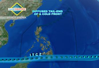
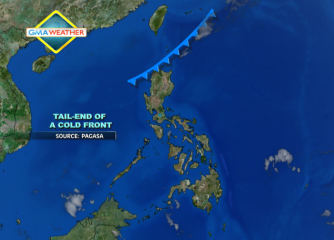
PAGASA said the low-pressure area (LPA) was estimated at 590 km northeast of Virac, Catanduanes as of 4 p.m., embedded in the inter-tropical convergence zone (ITCZ) affecting Bicol, Visayas and Mindanao.

“Mindanao, Western Visayas and Palawan will experience cloudy skies with moderate to occasionally heavy rains and thunderstorms which may trigger flash floods and landslides,” it said in its 5 p.m. bulletin.

It added Bicol and the rest of Visayas will have “cloudy skies with light to moderate rain showers and thunderstorms.”

On the other hand, Metro Manila and the rest of Luzon will be “partly cloudy with isolated rain showers or thunderstorms mostly in the afternoon or evening,” PAGASA said.

Earlier, PAGASA forecaster Elvie Enriquez said the LPA has a 50-50 chance of intensifying into a cyclone. Should it intensify into a cyclone while inside the Philippine area of responsibility, it will be codenamed Dante.

For Saturday, Metro Manila, Angeles and Olongapo Cities may expect temperatures of 25 to 34 degrees Celsius, while Tuguegarao City may expect temperatures of 25 to 36 degrees Celsius.

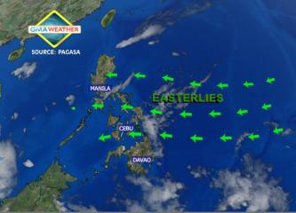
Meanwhile, PAGASA said moderate to occasionally strong winds from the northwest to west will prevail over Eastern Luzon and coming from the southwest over Palawan and the western section of Visayas and Mindanao.

The coastal waters along these areas will be moderate to occasionally rough, it added.

Also, PAGASA said light to moderate winds from the northwest to west will prevail over the rest of Luzon and coming from the southwest over the rest of the country with slight to moderate seas. — TJD, GMA News

Jun 072013
 
Heavy rain in Mindanao from LPA; at least 2 flights cancelled

Satellite Image at 7 a.m., June 6, 2013. | Weather Central At least two flights between Manila and Mindanao were canceled Friday afternoon due to bad weather, the Department of Transportation and Communications said. The DOTC said on its Twitter account the affected flights were those of Cebu Pacific, between Manila and Cagayan de Oro City. It said these included 5J-389 from Manila to Cagayan de Oro, and 5J-390 from Cagayan de Oro to Manila. As this developed, state weather forecasters warned of heavy rain in several parts of Mindanao, due to a potential cyclone. In a post on its Facebook page, PAGASA warned of heavy rain over Zamboanga del Norte, Misamis Occidental, Lanao del Norte, Davao del Norte, Misamis Oriental and portions of North Cotabato, Maguindanao, Agusan del Norte and Agusan del Sur. “Flooding is threatening in low-lying areas,” it said. PAGASA, in its 5 p.m. bulletin, also said a potential cyclone – a low-pressure area – may trigger flash floods and landslides in parts of Palawan, Western Visayas and Mindanao in the next 24 hours. “Mindanao, Western Visayas and Palawan will experience cloudy skies with moderate to occasionally heavy rains and thunderstorms which may trigger flash floods and landslides,” it said. — TJD, GMA News

Jun 062013
 
PAGASA: Potential cyclone nears Samar; floods, landslides threaten Vis-Min

Satellite Image at 7 a.m., June 6, 2013. | Weather Central Flash floods and landslides threaten parts of the Visayas and Mindanao as a potential cyclone or low-pressure area (LPA) moved closer to Eastern Samar early Friday, state weather forecasters said. PAGASA forecaster Elvie Enriquez said the LPA was estimated at 460 km east of Borongan City, Eastern Samar as of 4 a.m. “Ito bigyan natin ng 50-50 chance maging bagyong tropikal… Malapit na ito sa land mass,” she said in an interview on dzBB radio. She said the LPA is bringing rain to Eastern Samar, though it is not heavy as yet. Enriquez also said the LPA may cause the southwest monsoon to affect the country and start the rainy season. “[Pero] wala pa ang onset [ng rainy season], hindi pa,” she said. Should the LPA intensify into a cyclone while inside the Philippine area of responsibility, it will be locally codenamed Dante. Friday outlook PAGASA’s 5 a.m. bulletin said the LPA is embedded along the inter-tropical convergence zone affecting Bicol, Visayas and Mindanao. “Eastern Visayas, northern Mindanao and Zamboanga Peninsula will experience cloudy skies with moderate to occasionally heavy rains and thunderstorms which may trigger flash floods and landslides,” it said. It added Calabarzon, Mimaropa, Bicol region and the rest of Visayas and of Mindanao will have “cloudy skies with light to moderate rainshowers and thunderstorms.” Metro Manila and the rest of Luzon will be “partly cloudy to cloudy with isolated rainshowers or thunderstorms mostly in the afternoon Read More …

Jun 062013
 
Flashflood, landslide warnings up in Mindanao as potential cyclone nears PHL

Satellite Image at 7 a.m., June 6, 2013. | Weather Central A potential cyclone is now inside the Philippine area of responsibility and may head towards Mindanao, state weather forecasters said Thursday. PAGASA forecaster Alvin Pura said the LPA formed inside the Philippine area of responsibility (PAR) Thursday morning and is embedded within the inter-tropical convergence zone (ITCZ). “‘Yung inaasahang LPA nabuo na. Nariyan nakapaloob sa ITCZ … sa loob na ito (ng PAR),” Pura said in an interview on dzBB radio. But he said there is still no storm signal raised yet, as PAGASA is still monitoring the LPA to see whether or not it will intensify into a cyclone.  Should it become a cyclone, it will be locally codenamed Dante. Meanwhile, PAGASA forecaster Joey Figuracion said that there is also a chance that the disturbance may veer north towards Taiwan.  “Kung napunta sa area ng Pacific papuntang Japan, pwede maging ganap na bagyo,” Pura said. Flashflood, landslide warnings up in Mindanao PAGASA’s 11 a.m. advisory said the LPA and the ITCZ may trigger flash floods and landslides in Mindanao. It said that, as of 8 a.m., the LPA was estimated at 580 km east of Hinatuan, Surigao Del Sur, embedded in the ITCZ. “These weather systems will affect the Bicol region, Visayas and Mindanao,” it said, adding the whole Mindanao “will experience cloudy skies with moderate to heavy rains and thunderstorms which may trigger flash floods and landslides.” “Residents in these areas are advised to take all the Read More …

May 212013
 
PAGASA: No cyclone near PAR; rain likely over Luzon and Mindanao

Satellite Image at 7:30 a.m. Monday, 20 May 2013. | Weather Central Although there is still no cyclone near the Philippine area of responsibility, residents in parts of northern Luzon and Mindanao may expect rain on Wednesday, state weather forecasters said. PAGASA forecaster Bernie de Leon said the rain will come from a tail-end of a cold front affecting northern Luzon, while the inter-tropical convergence zone is affecting Mindanao. “Sa kasalukuyan wala pa tayong namamataang namumuong sama ng panahon sa Philippine area of responsibility. Subali’t nakaaapekto pa rin ang tail end of cold front sa northern Luzon at ITCZ ang nakakaapekto sa southern Mindanao,” de Leon said in an interview on dzBB radio. In Metro Manila, he said there will be generally good weather but with isolated rain showers and thunderstorms. PAGASA said Metro Manila may expect temperatures of 26 to 34 degrees Celsius while Tuguegarao City may expect temperatures of 24 to 32 degrees Celsius. Angeles and Olongapo Cities may expect temperatures of 25 to 32 degrees Celsius, it added. PAGASA’s 5 a.m. bulletin said: “The regions of Ilocos, Cordillera, Cagayan Valley in [northern Luzon], Davao and Zamboanga Peninsula [in Mindanao] will have cloudy skies with light to moderate rain showers and thunderstorms,” it said. It added Metro Manila and the rest of the country will be “partly cloudy with isolated rain showers or thunderstorms mostly over the western section.” Light to moderate winds from the southeast to south will prevail over Luzon and coming from the east to Read More …

May 092013
 
PAGASA: Rain over Mindanao, 38-degree Celsius weekend for Central Luzon

Satellite Image as of 7:30 a.m, 9 May 2013. | Weather Central Central Luzon is in for scorcher of a weekend as temperatures as high as 38 degrees Celsius was forecast. Meanwhile, rain was projected over parts of southern Luzon, western Visayas and Mindanao due to the inter-tropical convergence zone. PAGASA forecaster Ricky Fabregas on Friday said that while the ITCZ would be affecting Mindanao, the easterlies or warm winds from the east will be affecting the rest of the country. “Sa Election Day, ang Mindanao may high probability ng paulan dahil sa ITCZ. Sa Luzon at Visayas, mababa ang probability, mga isolated rain showers and thunderstorms,” Fabregas said in an interview on dzBB radio. He also said temperatures will be hot in Luzon on Election Day, at about 26 to 35 degrees Celsius. Visayas and Mindanao may expect cooler weather at 25 to 33 degrees Celsius. 38-degree Celsius weekend PAGASA’s extended outlook indicated temperatures of up to 38 degrees Celsius in Angeles and Olongapo Cities in Central Luzon. It said the two cities may expect temperatures of 25 to 37 degrees Celsius Friday, and 25 to 38 degrees Celsius Saturday and Sunday, before settling to 25 to 37 degrees Celsius on Monday. Metro Manila may expect temperatures of 25 to 35 degrees Celsius Friday and Saturday. Tuguegarao City may expect temperatures of 24 to 36 degrees Celsius Friday. Friday weather In its 5 a.m. bulletin, PAGASA said Mimaropa, western Visayas and Mindanao will have cloudy skies with light to Read More …

Apr 182013
 
PAGASA: Rain over parts of Mindanao, 36-degree Celsius likely over NCR

Satellite Image as of 7:30 a.m., 17 April 2013. | Weather Central Rain caused by the trough of a low-pressure area may fall over parts of Mindanao on Friday, while Metro Manila braces for another hot day with temperatures reaching 36 degrees Celsius, state weather forecasters said. PAGASA forecaster Chris Perez said there is no sign of any weather disturbance or potential cyclone that may enter the Philippines in the next 24 hours. “Sa Metro Manila at natitirang bahagi ng ating bansa, mainit at maalinsangan na panahon pa rin aasahan natin,” Perez said in an interview on dzBB radio. He said the forecast temperature for Metro Manila for Friday is between 24 and 36 degrees Celsius. PAGASA’s extended weather outlook indicated a maximum temperature of 36 degrees Celsius for Metro Manila also on Saturday. Tuguegarao, Angeles and Olongapo Cities may have a maximum temperature of 35 degrees Celsius on Saturday. Friday outlook PAGASA’s 5 a.m. bulletin said the trough of a low-pressure area is affecting southern Mindanao while the ridge of a high-pressure area is extending across Luzon. “Davao region, ARMM, SOCCSKSARGEN and the provinces of Agusan and Surigao del Sur will have cloudy skies with light to moderate rain showers and thunderstorms. Metro Manila and the rest of the country will be partly cloudy with isolated rain showers or thunderstorms,” it said. It added light to moderate winds from the east to southeast will prevail over Luzon and Visayas and coming from the east over Mindanao. The coastal waters Read More …

Apr 102013
 
PAGASA: Cold front to bring Cagayan Valley rain, warm weather anew elsewhere

Satellite Image as of 8 a.m., 10 April 2013. | Weather Central Rain from the diffused tail-end of a cold front may fall over the Cagayan Valley in northern Luzon on Thursday, while Metro Manila and other parts of the country may continue to expect warm weather, state weather forecasters said. PAGASA forecaster Ricky Fabregas said the easterlies, or warm winds from the east, are expected to prevail anew and bring hot weather to most of the country. “[Kahapon] nagkaroon ng shifting ng hangin from easterlies naging northeast, kaya binabaan ang forecast temperature. Ngayon nakita natin magpe-prevail ang easterlies kaya tumaas uli ang forecast,” Fabregas said in an interview on dzBB radio. He said Metro Manila may expect temperatures of 24 to 35 degrees Celsius Thursday. On Wednesday, Metro Manila had experienced a high of 35.3 degrees Celsius. PAGASA’s extended forecast said Tuguegarao City may experience temperatures of 23 to 34 degrees Celsius, while Olongapo and Angeles Cities may expect temperatures of 24 to 35 degrees Celsius. Thursday outlook PAGASA said the diffused tail-end of a cold front would affect northern Luzon Thursday. “Cagayan Valley will experience cloudy skies with light to moderate rain showers and thunderstorms. Metro Manila and the rest of the country will be partly cloudy with isolated rain showers or thunderstorms,” it said. It added moderate to strong winds from the northeast will prevail over Northern Luzon and its coastal waters will be moderate to rough. Elsewhere, winds will be light to moderate coming from the Read More …

Mar 142013
 
Rain expected over NCR, parts of Luzon this Friday

Satellite image at 8 a.m., 14 March 2013. | Weather Central After experiencing heavy rain and sleet from a passing thunderstorm Thursday afternoon, Metro Manila residents may still have to bring their umbrellas Friday, state weather forecasters said Thursday afternoon. PAGASA, in its 5 p.m. bulletin, said the tail-end of a cold front is still affecting Northern Luzon but may cause isolated rain showers or thunderstorms in the next 24 hours. “Cagayan Valley region and the provinces of Ilocos Norte and Apayao will experience cloudy skies with light rains. Metro Manila and the rest of the country will have partly cloudy skies with isolated rainshowers or thunderstorms,” it said. In its extended outlook, PAGASA said Metro Manila may expect “partly cloudy skies with brief rain” with temperatures ranging from 23 to 34 degrees Celsius. But for Saturday and Sunday, it said Metro Manila may expect partly cloudy skies with brief rain. Meanwhile, PAGASA said moderate to strong winds blowing from the northeast will prevail over Northern Luzon and its coastal waters will be moderate to rough. “Elsewhere, winds will be light to moderate blowing from northeast with slight to moderate seas,” it said. Meanwhile, PAGASA said strong to gale-force winds associated with the northeasterly winds may affect the seaboards of Northern Luzon. “Fishing boats and other small seacrafts are advised not to venture out into the sea while larger sea vessels are alerted against big waves,” it said. — TJD, GMA News

Mar 042013
 
Summer is almost here, but don't discount cyclones yet —PAGASA

Satellite image at 7 a.m., 4 March 2013. | Weather Central Just because summer is coming may not necessarily mean there will be no cyclone this month, state weather forecasters said Monday. PAGASA forecaster Jori Loiz said in a radio interview that “zero to one” cyclone is expected this month in the Philippine Area of Responsibility (PAR). “Meron tayong zero or one, there is a chance,” he said in an interview on dzBB radio. The next cyclone to enter the PAR will be codenamed “Dante,” the fourth cyclone to enter the area this year. The Philippines is finally looking forward to summer, as the northeast monsoon that brought cold weather to parts of the country continues to weaken. Loiz said the official announcement of summer may come as early as next week. But he said the northeast monsoon will make a “final surge” before finally bowing out in favor of the hot summer season. “Ang analysis namin sa China and ibang parte, medyo pahina na ang amihan. Pero nagkaroon ng surge pero inaasahan natin ang paglakas ng amihan bago mawala na,” he said. — TJD, GMA News