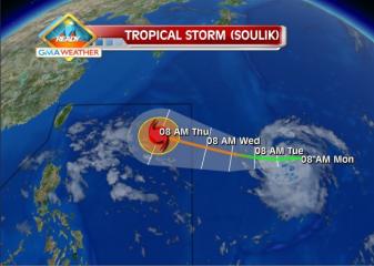
Tropical Storm Soulik forecast track as of 8Jul2013. The Weather Central forecast track for Soulik as of 8am Monday shows that the tropical storm may enter the northeastern corner of the Philippine Area of Responsibility by Wednesday. GMA News
Typhoon Soulik intensified further as it moved closer toward Batanes in extreme northern Luzon, and may enter the Philippine area of responsibility before noon Wednesday, state weather forecasters said.
PAGASA forecaster Samuel Duran also said Soulik, to be codenamed Huaning once it is inside the PAR, also slightly changed course and is now moving west-northwest.
“Babantayan natin kung sakali, baka sumubsob [sa kalupaan] dahil may lumalakas na high-pressure area na nakatuntong sa kanya kaya nahirapan siya mag-northward,” Duran said in an interview on dzBB radio.
He said their models indicate the possibility of Soulik – now with an 800 km diameter – making landfall over the Batanes area in extreme northern Luzon.
Duran said their models also indicate Soulik may enter the Philippine area of responsibility between 10 and 11 a.m.
While he said Soulik is not likely to affect Metro Manila, it may make itself felt by enhancing the southwest monsoon.
“Expect natin kung magtuloy-tuloy si Soulik, by tomorrow afternoon maranasan natin ang pag-ulan,” he said.
He added Soulik is expected to leave the Philippine area of responsibility by early Saturday.
As of 4 a.m., PAGASA said Soulik was estimated at 1,365 km east of Itbayat, Batanes, with maximum sustained winds of 150 kph near the center and gustiness of up to 185 kph.
PAGASA said Soulik is forecast to move west-northwest at 20 kph.
Wednesday outlook
For Wednesday, PAGASA said Mimaropa, Bicol, Western Visayas, Zamboanga Peninsula, Soccsksargen and the provinces of Quezon and Aurora will experience cloudy skies with light to moderate rain showers and thunderstorms.
Metro Manila and the rest of the country will be partly cloudy to cloudy with isolated rain showers or thunderstorms, it added.
Moderate to occasionally strong winds from the north to northwest will prevail over Luzon and its coastal waters will be moderate to occasionally rough.
Elsewhere, winds will be light to moderate coming from the southwest with slight to moderate seas. — DVM, GMA News
![]()