Jul 132013
 

TAIPEI—Typhoon Soulik battered Taiwan with torrential rain and powerful winds on Saturday that left one person dead and at least 30 people injured.

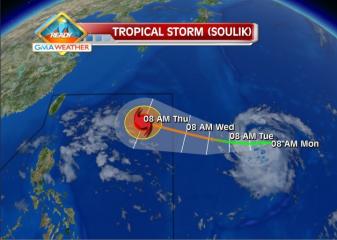
This as the typhoon, codenamed “Huaning” in the Philippines, left the country’s area of responsibility Saturday morning, prompting the lifting of all public storm alerts in extreme Northern Luzon.

As daylight dawned, some areas in Taiwan were submerged by flood waters, roofs were ripped from homes, and debris and fallen trees littered the streets.

More heavy rain and strong winds are predicted throughout Saturday with the authorities warning of landslides and further flooding.

More than 8,000 people were evacuated from their homes before the typhoon hit, many from southern areas prone to landslides.

Soldiers have been deployed to high risk areas and the whole island declared an “alert zone” by the authorities.

In the capital Taipei, a 50-year-old police officer died after being hit by bricks that came loose during the typhoon, the Central Emergency Operation Centre said.

Three people were left seriously injured with 31 reported hurt in four cities in northeast Taiwan, most of them hit by trees or flying debris.

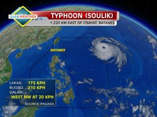
Soulik made landfall on the northeast coast around 03 a.m. Saturday (2000 GMT Friday), packing winds of up to 190 kilometers an hour (118 miles), the Central Weather Bureau said.

“We expect Soulik to continue to affect Taiwan with heavy rains and strong winds throughout Saturday across Taiwan even though it is moving away and heading towards China,” a weather forecaster from the bureau told Agence France-Presse.

Nine people had to be rescued from homes in the Shiangshan area of Puli in central Nantou county where flood waters rose one-storey high, according to Wu Yuan-ming, a township official.

“They had to be rescued by firefighters in rubber boats after the river broke its banks. Roads are flooded and mud has been washed into homes — this is more serious than we predicted as there has never been any flooding in Shiangshan before.

“Also an earthquake last month probably loosened the ground and triggered the mudslides,” said Wu.

TV footage showed waist-deep yellow water flowing through the streets of the town of Wufeng, also in Nantou.

The town of Bailan in the north saw the heaviest rain, measuring 900 millimeters (35 inches) over the past two days, with winds gusting up to 220 kilometres per hour.

Streets were submerged under 30 centimeters of seawater in the port city of Keelung, the National Fire Agency said, with flooding also reported in the coastal area of Yilan and in New Taipei City, northwest of the capital.

Low-lying houses along the Hsintien River through greater Taipei were flooded, including one village where residents had been evacuated Friday, a local police officer told AFP.

Local television showed roofs ripped from homes in northern Keelung and in Taipei, where 120 kilometre-per-hour winds and downpours disrupted power, uprooted trees and left the streets strewn with rubbish.

“I was very worried, I couldn’t sleep the whole night because the sound of the wind was so loud and my building was shaking almost like there was an earthquake,” Taipei resident Josephine Lin told AFP.

Across Taiwan, electricity supplies in nearly 800,000 homes cut off by the typhoon but half had been restored by Saturday morning, according to Taiwan Power Company.

Around 170 flights into and out of Taiwan were cancelled or delayed.

Hundreds of passengers on three international flights with Taiwan’s EVA Airways were trapped on their planes for six hours early Saturday, CTI cable news reported. The three aircraft departed later.

Offices and schools remained closed across Taiwan, with the public advised to stay indoors.

In August 2009, Typhoon Morakot killed about 600 people in Taiwan, most of them buried in huge landslides in the south, in one of the worst natural disasters to hit the island in recent years.

A public bus maneuvers through a path of debris from strong winds of Typhoon Soulik early Saturday in Taipei, Taiwan. AP

Follow Us

Recent Stories:

Complete stories on our Digital Edition newsstand for tablets, netbooks and mobile phones; 14-issue free trial. About to step out? Get breaking alerts on your mobile.phone. Text ON INQ BREAKING to 4467, for Globe, Smart and Sun subscribers in the Philippines.

Tags: Huaning , Philippines , Soulik , Taiwan , Typhoon , weather

Factual errors? Contact the Philippine Daily Inquirer’s day desk. Believe this article violates journalistic ethics? Contact the Inquirer’s Reader’s Advocate. Or write The Readers’ Advocate:

Jul 112013
 
PAGASA: Typhoon Huaning moving toward Batanes-Taiwan area

Typhoon Soulik enters PAR, codenamed Huaning. Tropical Storm Soulik, visible as a white circular cloud formation in the upper righthand portion of this image, passed into the Philippine Area of Responsibility at around 10am (PHT) on July 10. It has been given the local codename, Huaning. GMA News Typhoon Huaning (Soulik) maintained its strength as it moved toward the Batanes-Taiwan area Thursday afternoon, state weather forecasters said. PAGASA forecaster Aldczar Aurelio said Huaning is not likely to make landfall over the Philippines so long as it does not change its present course. “Hindi sya magla-landfall basta ma-maintain ang course,” Aurelio said in an interview on dzBB radio. But he said Huaning has a diameter of 900 km and may bring heavy rain to parts of Batanes, which is under Storm Signal No. 1. PAGASA’s 5 p.m. advisory said Huaning has maintained its strength as it moves in the general direction towards the Taiwan-Batanes area. As of 4 p.m., it was estimated at 690 km east-northeast of Itbayat, Batanes. Huaning packed maximum winds of 185 kph near the center and gustiness of up to 220 kph, and was moving west-northwest at 20 kph. By Friday afternoon, it is expected to be 410 km northeast of Itbayat, Batanes. By Saturday afternoon it is expected to be 540 km north-northwest of Itbayat, Batanes and outside the Philippine Area of Responsibility. PAGASA said Huaning may bring rainfall of 10 to 46 mm per hour (heavy to torrential) within its 900-km diameter. “Fishermen specially those Read More …

Jul 102013
 
PAGASA: Signal 1 over Batanes; Huaning effects expected starting Thursday

Typhoon Soulik enters PAR, codenamed Huaning. Tropical Storm Soulik, visible as a white circular cloud formation in the upper righthand portion of this image, passed into the Philippine Area of Responsibility at around 10am (PHT) on July 10. It has been given the local codename, Huaning. GMA News The Batanes islands were placed under Storm Signal No. 1 Wednesday afternoon as Typhoon Huaning (Soulik) continued moving toward Northern Luzon, state weather forecasters said. But PAGASA forecaster Jori Loiz said their models indicate Huaning may still not make itself felt until at least Thursday or Friday. “Hindi tatama sa Pilipinas ang bagyong si Huaning,” Loiz said in an interview on dzBB radio. Loiz said their models indicate Huaning may eventually head for Taiwan, though it may enhance the southwest monsoon that will bring rain over parts of the Philippines. The typhoon is still likely to leave the Philippine area of responsibility by early Saturday, he added. “Ang pag-ulan sa habagat maaring Friday afternoon or Saturday,” he said. Advisory In its 5 p.m. advisory, PAGASA said Huaning was estimated at 1,150 km east of Itbayat, Batanes as of 4 p.m. According to PAGASA, Huaning packed maximum winds of 175 kph near the center and gustiness of up to 210 kph, and was moving west-northwest at 20 kph. By Thursday afternoon, it is expected to be 720 km northeast of Itbayat, Batanes. By Friday afternoon it is expected to be 380 km northeast of Itbayat, Batanes. On Saturday afternoon, it is expected to Read More …

Jul 092013
 
PAGASA: Typhoon Soulik may enter PAR before noon, landfall not discounted

Tropical Storm Soulik forecast track as of 8Jul2013. The Weather Central forecast track for Soulik as of 8am Monday shows that the tropical storm may enter the northeastern corner of the Philippine Area of Responsibility by Wednesday. GMA News Typhoon Soulik intensified further as it moved closer toward Batanes in extreme northern Luzon, and may enter the Philippine area of responsibility before noon Wednesday, state weather forecasters said. PAGASA forecaster Samuel Duran also said Soulik, to be codenamed Huaning once it is inside the PAR, also slightly changed course and is now moving west-northwest. “Babantayan natin kung sakali, baka sumubsob [sa kalupaan] dahil may lumalakas na high-pressure area na nakatuntong sa kanya kaya nahirapan siya mag-northward,” Duran said in an interview on dzBB radio. He said their models indicate the possibility of Soulik – now with an 800 km diameter – making landfall over the Batanes area in extreme northern Luzon. Duran said their models also indicate Soulik may enter the Philippine area of responsibility between 10 and 11 a.m. While he said Soulik is not likely to affect Metro Manila, it may make itself felt by enhancing the southwest monsoon. “Expect natin kung magtuloy-tuloy si Soulik, by tomorrow afternoon maranasan natin ang pag-ulan,” he said. He added Soulik is expected to leave the Philippine area of responsibility by early Saturday. As of 4 a.m., PAGASA said Soulik was estimated at 1,365 km east of Itbayat, Batanes, with maximum sustained winds of 150 kph near the center and gustiness of Read More …