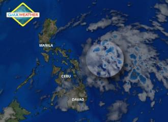
Satellite Image at 7 a.m., June 6, 2013. | Weather Central
Flash floods and landslides threaten parts of the Visayas and Mindanao as a potential cyclone or low-pressure area (LPA) moved closer to Eastern Samar early Friday, state weather forecasters said.
PAGASA forecaster Elvie Enriquez said the LPA was estimated at 460 km east of Borongan City, Eastern Samar as of 4 a.m.
“Ito bigyan natin ng 50-50 chance maging bagyong tropikal… Malapit na ito sa land mass,” she said in an interview on dzBB radio.
She said the LPA is bringing rain to Eastern Samar, though it is not heavy as yet.
Enriquez also said the LPA may cause the southwest monsoon to affect the country and start the rainy season.
“[Pero] wala pa ang onset [ng rainy season], hindi pa,” she said.
Should the LPA intensify into a cyclone while inside the Philippine area of responsibility, it will be locally codenamed Dante.
Friday outlook
PAGASA’s 5 a.m. bulletin said the LPA is embedded along the inter-tropical convergence zone affecting Bicol, Visayas and Mindanao.
“Eastern Visayas, northern Mindanao and Zamboanga Peninsula will experience cloudy skies with moderate to occasionally heavy rains and thunderstorms which may trigger flash floods and landslides,” it said.
It added Calabarzon, Mimaropa, Bicol region and the rest of Visayas and of Mindanao will have “cloudy skies with light to moderate rainshowers and thunderstorms.”
Metro Manila and the rest of Luzon will be “partly cloudy to cloudy with isolated rainshowers or thunderstorms mostly in the afternoon or evening,” it added.
PAGASA also said light to moderate winds from the southeast will prevail over northern Luzon and coming from the southeast to south over the rest of the country.
The coastal waters throughout the archipelago will be slight to moderate. — DVM, GMA News
![]()