Jan 272014
 

Nearly P80 million in assistance has been given to families in Visayas and Mindanao who were affected earlier this month by a low-pressure area that intensified into Tropical Depression Agaton (Lingling).

The National Disaster Risk Reduction and Management Council said some P79,803,510.81 was extended by government agencies and non-government organizations.

In its 6 a.m. update, the NDRRMC said a breakdown of the amount included:
  • P40,154,571.21 from the Department of Social Welfare and Development
  • P35,486,090.55 from local government units
  • P2,059,685 from non-government and government organizations

The NDRRMC indicated the assistance was given to residents of Regions 5, 10, 11, 12 and Caraga.

As of Tuesday morning, the death toll from Agaton remained at 64, with 85 injured and 10 still missing.

The NDRRMC said 244,344 families or 148,621 people were affected in 1,002 villages in 118 towns in 16 provinces.

Of these, 21,062 families or 102,201 people were displaced and are staying in 228 evacuation centers.

Damage was estimated at P509,905,686.72, including P256,413,750 in infrastructure and P253,491,936.72 in agriculture. —KG, GMA News

Nov 232013
 
Five flights to Caticlan cancelled due to bad weather – DOTC

Cebu Pacific and Philippine Airlines Express have cancelled a total of five flights to Caticlan, Aklan Saturday due to bad weather,  the Department of Transportation and Communications (DOTC) said. On Twitter, DOTC stated that Cebu Pacific flights 5J-897 and 5J-895 (Manila to Caticlan), 5J-896 5J-898 (Caticlan to Manila) have been cancelled. Philippine Airlines Express, meanwhile, has cancelled flight  2P-046 bound from Caticlan to Manila.  PAGASA earlier said a low pressure area (LPA) will bring moderate to heavy rain over the central and southern parts of the Philippines. The weather bureau’s 5 a.m. forecast said Palawan, Visayas and the regions of Zamboanga Peninsula, northern Mindanao and CARAGA will experience cloudy skies with moderate to occasionally heavy rainshowers and thunderstorms due to the LPA. In a statement, Cebu Pacific said passengers affected by the flight cancellation may rebook their flights for travel within 30 days from original departure date. They may also opt for a refund without incurring any penalties. – Xianne Arcangel / KDM, GMA News 

Sep 082013
 
PAGASA tracking LPA near Northern Samar

State weather forecasters are now tracking a low-pressure area—a potential cyclone—off Northern Samar in Eastern Visayas. PAGASA, in its 5 p.m. bulletin, said the LPA was estimated in the vicinity of Catarman, Northern Samar as of 4 p.m. It said the LPA was embedded along the inter-tropical convergence zone across Palawan, Visayas and Mindanao and may trigger flash floods and landslides in parts of Southern Luzon. Should the LPA intensify into a cyclone, it will be codenamed Odette. Flash floods, landslides “Calabarzon and the provinces of Mindoro and Marinduque will experience cloudy skies with moderate to occasionally heavy rains and thunderstorms which may trigger flash floods and landslides,” PAGASA said. It added Metro Manila and the rest of the country will have “cloudy skies with light to moderate rainshowers and thunderstorms.” Also, PAGASA’s extended weather outlook expected most major cities will be cloudy with rain showers or thunderstorms on Monday. Only Metro Davao and Zamboanga, Tuguegarao and Laoag Cities will be partly cloudy to cloudy with isolated rain showers or thunderstorms, it added. Monday outlook Meanwhile, PAGASA said moderate to occasionally strong winds from the northeast will prevail over extreme Northern Luzon and its coastal waters will be moderate to occasionally rough. Light to moderate winds coming from the northeast to north will prevail over the rest of Luzon and from the southwest to south over the rest of the country with slight to moderate seas. — BM, GMA News

Aug 032013
 
LPA nears Cebu; floods, landslides threaten Palawan, Vis-Min

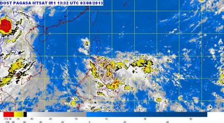
Rain clouds over much of the Visayas, Mindanao and Bicol. “Eastern Visayas, Caraga and Davao region will experience moderate to occasionally heavy rainshowers and thunderstorms which may trigger flashfloods and landslides,” PAGASA said in its 5:00 p.m. weather bulletin Saturday. PAGASA added that “Palawan, Bicol region and the rest of Visayas and Mindanao will have cloudy skies with light to moderate rainshowers and thunderstorms.” PAGASA Residents in parts of Palawan, Visayas and Mindanao were advised before noon Sunday to brace for possible flash floods and landslides as a potential cyclone moved near Cebu. State weather forecasters said the potential cyclone, a low-pressure area, was estimated in the vicinity of Mactan, Cebu as of 8 a.m. In its 11 a.m. advisory, PAGASA said the LPA is embedded along the inter-tropical convergence zone. “These weather systems are expected to bring moderate to occasionally heavy rains and thunderstorms in Palawan, Visayas and regions of Zamboanga Peninsula Northern Mindanao, ARMM and SOCCSKSARGEN which may trigger flash floods and landslides,” it said. “Residents in these areas are advised to take all the necessary precautionary measures,” it added. Earlier, PAGASA forecaster Joey Figuracion said the LPA has a low chance of becoming a cyclone. But if it does, it will be codenamed Kiko. — LBG, GMA News

Aug 022013
 
LPA moves closer to south Mindanao, rain expected over parts of Luzon Saturday

Rain may fall over parts of Metro Manila and other parts of Luzon as well as Mindanao on Saturday, as a potential cyclone—a low-pressure area (LPA)—moved closer to southern Mindanao Friday afternoon, state weather forecasters said. PAGASA said the LPA was estimated at 960 km east of southern Mindanao as of 4 p.m., even as a weak southwest monsoon will affect the western section of Luzon. “The provinces of Zambales, Bataan, Batangas, Mindoro, Palawan, Surigao, and Davao Oriental will have cloudy skies with light to moderate rain showers and thunderstorms,” PAGASA said in its 5 p.m. bulletin. It added Metro Manila and the rest of the country will be “partly cloudy to cloudy with isolated rain showers or thunderstorms.” Earlier, PAGASA said there is still a chance the LPA may intensify into a cyclone as it is still at sea and can gather strength. Saturday outlook PAGASA said moderate to strong winds from the southwest to south will prevail over the western section of Luzon and the coastal waters along this area will be moderate to rough. Light to moderate winds coming from the southeast to south will prevail over the rest of Luzon and from the northeast to northwest over Visayas and Mindanao with slight to moderate seas. Meanwhile, PAGASA said strong to gale-force winds associated with the southwest monsoon may affect the western seaboard of northern and Central Luzon. “Fishing boats and other small seacrafts are advised not to venture out into the sea while larger sea vessels Read More …

Jul 272013
 
LPA in Davao Oriental; floods, landslides threaten Bicol, Vis-Min

A potential cyclone, a low-pressure area, moved to Davao Oriental in Mindanao Saturday afternoon, even as state weather forecasters warned of flash floods and landslides over Bicol in southern Luzon, Visayas and Mindanao in the next 24 hours. PAGASA said that as of 4 p.m., the LPA was estimated at the vicinity of Davao Oriental, embedded in the Inter-tropical Convergence Zone affecting Palawan, Visayas and Mindanao. “Bicol region, Visayas and Mindanao will experience cloudy skies with moderate to heavy rain showers and thunderstorms, which may trigger flash floods and landslides,” PAGASA said in its 5 p.m. bulletin. Also, it said Metro Manila, Calabarzon and Mimaropa will have “cloudy skies with light to moderate rain showers and thunderstorms.” PAGASA’s extended weather forecast for Metro Manila indicated cloudy skies with rain showers or thunderstorms until July 31. The rest of Luzon will be “partly cloudy to cloudy with isolated rain showers or thunderstorms,” PAGASA added. Earlier, PAGASA said that if the LPA became a cyclone, it would be locally codenamed “Jolina.” Meanwhile, PAGASA said moderate to occasionally strong winds from the southwest will prevail over Palawan and Mindanao and the coastal waters along these areas will be moderate to occasionally rough. — LBG, GMA News

Jul 192013
 
DA bans birds, poultry products from S Africa

MANILA, Philippines – The Department of Agriculture (DA) has temporarily banned the importation of wild birds, poultry and poultry products from South Africa because of an outbreak of low pathogenic avian (LPAI) influenza there. The ban issued on July 8, 2013 is meant to protect the health of the local poultry population and of consumers. In a memorandum, Agriculture Secretaray Proceso Alcala said the outbreak was confirmed by the Office Internationale Epizooties (OIE). Presence of LPA serotype H7N7 was seen in a commercial ostrich farm in Oudtshoorn, Western Cape Province. The LPAI virus was confirmed through real-time polymerase chain reaction conducted by the Agricultural Research Council-Ondersteproof veterinary Institute National Laboratory. Also covered by the ban are day-old chicks, eggs and semen from the Land of Lower Saxony. Business ( Article MRec ), pagematch: 1, sectionmatch: 1 The government has suspended the processing and issuance of veterinary quarantine clearance for such products. All shipments of such commodities, with the exemption of heat treated products will shall be confiscated at major ports.

Jul 032013
 
PAGASA: Weather disturbance off Mindoro unlikely to become cyclone

A weather disturbance, a low-pressure area, off Mindoro has a slim chance of becoming a cyclone, at least while it is inside the Philippine area of responsibility, state weather forecasters said Thursday. PAGASA forecaster Alvin Pura said the LPA, which is 170 km west of Calapan in Mindoro Oriental, is moving away from the Philippines. “Hindi ito inaasahang maging bagyo sa loob ng Philippine Area of Responsibility (PAR),” Pura said in an interview on dzBB radio. But should the LPA become a cyclone within the PAR, it will be locally codenamed “Huaning,” he said. In the meantime, Pura said the LPA may bring light to moderate rain. Earlier, PAGASA said the LPA may enhance the Inter-tropical Convergence Zone now affecting Southern Luzon and Visayas. — LBG, GMA News

Jun 272013
 
PAGASA: LPA off Surigao intensifies into TD Gorio

A low-pressure area east of Surigao on Thursday night intensified into a tropical depression and was locally codenamed Gorio. PAGASA, in its 11 p.m. advisory, said Tropical Depression Gorio was estimated at 520 km east of Surigao City, with maximum winds of 45 kph near the center. Tropical Depression Gorio was forecast to move north-northwest at 7 kph. PAGASA said Gorio is forecast to be 420 km east of Surigao City by Friday evening. By Saturday evening, it is expected to be 410 km northeast of Surigao City, and about 270 km east of Virac, Catanduanes by Sunday evening. PAGASA said Gorio may bring rainfall of 5 to 15 mm per hour (moderate to heavy) within its 300-km diameter. Also, the weather service said Tropical Depression Gorio will enhance the southwest monsoon, “which will bring moderate to occasionally heavy rains and thunderstorms over the eastern section of Visayas and Mindanao.” PAGASA advised the public and disaster coordinating councils concerned to take appropriate actions. — DVM, GMA News

Jun 162013
 
PAGASA: TD Emong to affect PHL till Friday; LPA may form off Ilocos

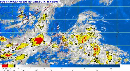
PAGASA: ‘Habagat’, LPA, ITCZ bring rain to various parts of PHL. PAGASA said in its weather bulletin early Sunday morning that the Bicol region, Central and Eastern Visayas and Mindanao will experience cloudy skies with moderate to occasionally heavy rainshowers and thunderstorms which may trigger flash floods and landslides.” PAGASA Tropical Depression Emong will affect parts of the Philippines until at least Friday, state weather forecasters said. PAGASA forecaster Jun Galang also said they are monitoring a cloud formation that could become a low-pressure area off Ilocos later this week. “[Ang epekto nito] itong buong week hanggang Friday. Kung walang pagbabago by Thursday makakalabas ng Philippine area of responsibility,” Galang said in a Monday interview on dzBB radio. While Tropical Depression Emong was too far to directly affect any part of the country, it would enhance the southwest monsoon, which will bring rain mainly to Luzon and Visayas. He also said that as Emong moved northward, the weather in Mindanao would gradually improve while Luzon and Visayas can expect more rain. Meanwhile, Galang said there was a chance a low-pressure area would form off Laoag in Ilocos Norte province later this week. “Papalabas siya may chance mabuo na LPA west ng Laoag, makakadagdag sa epekto ng habagat,” he said. Emong PAGASA’s 5 a.m. bulletin said that as of 4 a.m. Monday, Emong was estimated to be 300 km east of Virac, Catanduanes. It had maximum sustained winds of 55 kph near the center and was forecast to move north-northwest at Read More …