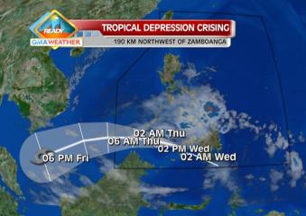
Predicted track for TD Crising as of 20Feb2013. TD Crising is expected to leave the Philippine Area of Responsibility by early morning tomorrow, Thursday, 21Feb2013. Weather Central
Tropical Depression (TD) Crising slowed down as it crossed the Sulu Sea before noon Wednesday, even as two areas were placed under Storm Signal No. 1, state weather forecasters said.
PAGASA, in its 11 a.m. advisory, said Tropical Depression Crising was estimated at 220 km northwest of Zamboanga City as of 10 a.m.
It said Crising packed maximum winds of 45 kph near the center and is moving west-northwest at 19 kph.
By Thursday morning, PAGASA said Crising is expected to be 280 km southwest of Puerto Princesa City. By Thursday evening, it estimated Crising to be 480 km southwest of Puerto Princesa City.
Under Storm Signal No. 1 are Southern Palawan and Zamboanga del Norte. Storm warning signals in other areas had been lowered, PAGASA said.
It said Crising may bring rainfall of 5 to 15 mm per hour (moderate to heavy) within its 300-km diameter.
“Residents living in low-lying and mountainous areas under Storm Signal No. 1 are alerted against possible flash floods and landslides,” PAGASA said.
PAGASA also reminded fishing boats and other small seacraft against going out into the northern, eastern and southern seaboards of Luzon, the central and eastern seaboards of Visayas and eastern seaboard of Mindanao.
LPA off Puerto Princesa
Meanwhile, PAGASA said a low-pressure area northwest of Puerto Princesa City has dissipated. — TJD, GMA News
![]()