Feb 202013
 
NDRRMC: Death toll from 'Crising' rises to 2; 120k people affected

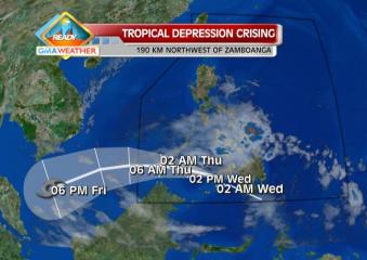
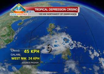
Satellite image at 8 a.m., 20 Feb 2013. Tropical Depression Crising at 8 a.m., 20 Feb 2013 Weather Central The death toll from Tropical Depression Crising rose to two as of Thursday morning, the National Disaster Risk Reduction and Management Council said. In its 6 a.m. update, the NDRRMC said the most recent fatality was Erwin Campana, 43, who drowned while crossing a river in Montevista town’s Barangay Camansi in Compostela Valley. Earlier, the NDRRMC said the other fatality – Francisco Digaynon – drowned while crossing the Taytayan River in Barangay Andap in New Bataan, Compostela Valley. Moreover, the NDRRMC said the number of missing people also rose to two. The latest was identified as Suden Abdullah, who went missing while on his way home. It said Abdullah, a resident of Barangay Pinol in Maitum in Sarangani province, was on his way home from fishing when his boat encountered big waves. Earlier, 63-year-old Percela R. Apolinario was reported missing while crossing the river in Brgy. Magugba. The NDRRMC said Crising has affected 25,350 families or 120,269 people in 80 villages in Regions 9, 10, 11 and 12. Of these, 864 families or 3,950 people were brought to seven evacuation centers. At least seven roads and six bridges were affected in Regions 8, 10, 11, and 12. The NDRRMC also said at least two houses in Regions 10 and 11 were destroyed while 85 were damaged. Meanwhile, the Department of Social Welfare and Development recorded 23,000 affected families, DSWD-Disaster Risk Reduction Read More …

Feb 192013
 
TD Crising slows down, but storm signals still hoisted

Predicted track for TD Crising as of 20Feb2013. TD Crising is expected to leave the Philippine Area of Responsibility by early morning tomorrow, Thursday, 21Feb2013. Weather Central Tropical Depression (TD) Crising slowed down as it crossed the Sulu Sea before noon Wednesday, even as two areas were placed under Storm Signal No. 1, state weather forecasters said. PAGASA, in its 11 a.m. advisory, said Tropical Depression Crising was estimated at 220 km northwest of Zamboanga City as of 10 a.m. It said Crising packed maximum winds of 45 kph near the center and is moving west-northwest at 19 kph. By Thursday morning, PAGASA said Crising is expected to be 280 km southwest of Puerto Princesa City. By Thursday evening, it estimated Crising to be 480 km southwest of Puerto Princesa City. Under Storm Signal No. 1 are Southern Palawan and Zamboanga del Norte. Storm warning signals in other areas had been lowered, PAGASA said. It said Crising may bring rainfall of 5 to 15 mm per hour (moderate to heavy) within its 300-km diameter. “Residents living in low-lying and mountainous areas under Storm Signal No. 1 are alerted against possible flash floods and landslides,” PAGASA said.  PAGASA also reminded fishing boats and other small seacraft against going out into the northern, eastern and southern seaboards of Luzon, the central and eastern seaboards of Visayas and eastern seaboard of Mindanao. LPA off Puerto Princesa  Meanwhile, PAGASA said a low-pressure area northwest of Puerto Princesa City has dissipated. — TJD, GMA News

Feb 122013
 
Moderate rains expected over Eastern Luzon, Visayas

Satellite image at 8 a.m., 13 Feb 2013. Satellite image at 8 a.m., 13 Feb 2013 Weather Central Rain may fall over the eastern parts of Luzon and Visayas due to the northeast monsoon on Wednesday, state weather forecasters said. PAGASA forecaster Buddy Javier also said Metro Manila is no longer likely to experience a repeat of Tuesday’s surprise rain showers. “Kahapon kasi kaya tayo inulan, lumakas ang northeast monsoon at tumagos sa Luzon, umabot sa Metro Manila. Light rain lang naman,” Javier said in an interview on dzBB radio. Effects of Amihan monsoon “The northeast monsoon has strengthened as it now affects the entire eastern sections of Luzon and Visayas.  For the whole day today, light to moderate rainshowers or thunderstorms should be expected over eastern —Samar and Leyte provinces—  and central —Cebu and Bohol— sections of  Visayas and the whole of Mindanao, particularly in CARAGA and Davao regions,” said GMA resident meteorologist Nathaniel “Mang Tani” Cruz. “Bicol, Quezon, and parts of southern Luzon –particularly MIMAROPA)— as well as Batanes and extreme northern Luzon will also have light rains today,” he added.   24-hour weather forecast ending 8 a.m., February 14, 2013  In its 5 a.m. bulletin, PAGASA also said the northeast monsoon is affecting Eastern Luzon and Eastern Visayas. PAGASA said Eastern and Central Visayas and Caraga will have cloudy skies with light to moderate rain showers and thunderstorms. Cagayan Valley, Aurora and Quezon provinces, and Bicol will experience cloudy skies with light rain. Metro Manila and the rest Read More …

Feb 082013
 
New LPA tracked off GenSan as Amihan returns

Satellite image at 7 a.m., 8 Feb 2013. Satellite image at 7 a.m., 8 Feb 2013 Weather Central State weather forecasters on Friday afternoon started tracking a potential cyclone —a low-pressure area— off Mindanao, even as the northeast monsoon is starting to make itself felt again. PAGASA, in its 5 p.m. bulletin, said the LPA was estimated at 500 km east of General Santos City, even as the northeast monsoon is affecting Extreme Northen Luzon. However, PAGASA did not immediately say if the LPA has a strong chance of intensifying into a cyclone. If it becomes a cyclone, it will be codenamed Crising. Earlier, PAGASA had said there may be “zero to one” cyclone that may enter the Philippine area of responsibility in February. Rain over parts of PHL For the next 24 hours, PAGASA said Batanes and Calayan islands will experience cloudy skies with light rain. “Mindanao will have cloudy skies with light to moderate rain showers and thunderstorms,” it added. The rest of the country will be partly cloudy with isolated rain showers or thunderstorms particularly over Bicol and Eastern Visayas. Also, PAGASA said moderate to strong winds blowing from the northeast will prevail over Luzon, Eastern Visayas and Eastern Mindanao and the coastal waters along these areas will be moderate to rough. Elsewhere, winds will be light to moderate coming from the northeast with slight to moderate seas. — TJD, GMA News

Feb 072013
 
Transition to summer may come mid-February –PAGASA

Satellite image at 7 a.m., 7 Feb 2013. Satellite image at 7 a.m., 7 Feb 2013 Weather Central The transition to the hot summer season may come as early as mid-February —or sometime next week, state weather forecasters said Thursday. PAGASA forecaster Aldczar Aurelio also said that while the northeast monsoon may make its last hurrah this weekend, it will not bring very cold weather anymore. “Sa kalagitnaan ng Pebrero, wala na halos ang amihan. Susunod niyan transition period, toward na sa mainit na panahon,” Aurelio said in an interview on dzBB radio. Once the northeast monsoon is gone, he said a high-pressure area or warm winds from the east may cause warm weather, he said. But for now, he said the northeast monsoon may now be affecting parts of Northern Luzon and almost the entire Luzon this weekend. “Huwag asahan ang lamig tulad nung sa January. Ang temperatura bahagyang tataas, papunta tayo transition period (Just don’t expect the northeast monsoon to cause temperatures to fall like they did last January. After this, expect temperatures to go up as we head toward the transition period),” he said. “Asahan natin ang amihan pero hindi ganito kalakasan (We can expect the northeast monsoon to come but it won’t be as strong as before),” he added. Easterlies, isolated rain in next 24 hrs Meanwhile, PAGASA’s 5 p.m. bulletin said easterlies, or warm winds from the east, are still affecting the eastern section of the country. “The whole country will be partly cloudy with Read More …