Sep 082013
 
PAGASA tracking LPA near Northern Samar

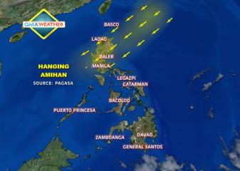
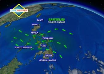
State weather forecasters are now tracking a low-pressure area—a potential cyclone—off Northern Samar in Eastern Visayas. PAGASA, in its 5 p.m. bulletin, said the LPA was estimated in the vicinity of Catarman, Northern Samar as of 4 p.m. It said the LPA was embedded along the inter-tropical convergence zone across Palawan, Visayas and Mindanao and may trigger flash floods and landslides in parts of Southern Luzon. Should the LPA intensify into a cyclone, it will be codenamed Odette. Flash floods, landslides “Calabarzon and the provinces of Mindoro and Marinduque will experience cloudy skies with moderate to occasionally heavy rains and thunderstorms which may trigger flash floods and landslides,” PAGASA said. It added Metro Manila and the rest of the country will have “cloudy skies with light to moderate rainshowers and thunderstorms.” Also, PAGASA’s extended weather outlook expected most major cities will be cloudy with rain showers or thunderstorms on Monday. Only Metro Davao and Zamboanga, Tuguegarao and Laoag Cities will be partly cloudy to cloudy with isolated rain showers or thunderstorms, it added. Monday outlook Meanwhile, PAGASA said moderate to occasionally strong winds from the northeast will prevail over extreme Northern Luzon and its coastal waters will be moderate to occasionally rough. Light to moderate winds coming from the northeast to north will prevail over the rest of Luzon and from the southwest to south over the rest of the country with slight to moderate seas. — BM, GMA News

Jul 242013
 
PAGASA: Rain over Luzon and Eastern Visayas Thursday

Rain is expected over Metro Manila, Luzon and Eastern Visayas on Thursday due to the inter-tropical convergence zone (ITCZ), state weather forecasters said. PAGASA, in its 5 p.m. bulletin, said the ITCZ was across northern and Central Luzon. For Thursday, it said Metro Manila, the rest of Luzon and Eastern Visayas may expect “cloudy skies with light to moderate rain showers and thunderstorms.” The rest of the country will be “partly cloudy to cloudy with isolated rain showers or thunderstorms.” Also, PAGASA said moderate to occasionally strong winds from the southeast to south will prevail over the Western section of Northern and Central Luzon and its coastal waters will be moderate to occasionally rough. Elsewhere, winds will be light to moderate coming from the east to southeast with slight to moderate seas. Thunderstorm advisories Earlier Wednesday, heavy rain was noted over parts of Metro Manila and Davao. Affected by thunderstorms were Davao City, parts of Davao del Sur, Davao del Norte, Bukidnon, Cotabato, and Maguindanao. PAGASA also issued thunderstorm advisories at 10 p.m. over: – Liloan, Consolation, Mandaue, LapuLapu in Cebu and nearby areas – Metro Manila — DVM, GMA News

Jul 062013
 
PAGASA: Cloudy skies, rainy weather over much of PHL Sunday

Cloudy skies and rainy weather may prevail over several parts of the country in the next 24 hours due to the Inter-tropical Convergence Zone, state weather forecasters said Saturday afternoon. PAGASA, in its 5 p.m. bulletin, said the ITCZ is affecting mainly Palawan and Mindanao, even as parts of Southern Luzon, Bicol, Visayas and Mindanao may expect rain. “Mimaropa, Bicol region, Eastern Visayas and Mindanao will experience cloudy skies with light to moderate rain showers and thunderstorms,” it said. It added Metro Manila and the rest of the country will be “partly cloudy to cloudy with isolated rain showers or thunderstorms.” PAGASA also said light to moderate winds from the east to southeast will prevail over Luzon and Visayas and coming from the east over Mindanao. The coastal waters throughout the archipelago will be slight to moderate, it added. Earlier, PAGASA forecasters said they do not expect any low-pressure area or cyclone this weekend, though the ITCZ may bring rain. — LBG, GMA News

Jun 292013
 
NDRRMC: Storm Gorio leaves 10k people stranded, roads impassable

A total of 10,064 people were stranded while at least two roads in Eastern Visayas were impassable in the wake of Tropical Storm Gorio (Rumbia), the National Disaster Risk Reduction and Management Council said Saturday evening. In its 6 p.m. update, the NDRRMC said the stranded were in Central Visayas, Southern Luzon, Bicol, Northern Mindanao and Eastern Visayas. The NDRRMC said 83 vessels, 1,031 rolling cargoes and 21 motor bancas were also stranded. Of the 10,064 stranded passengers, 2,604 were from Southern Luzon, 2,949 from Bicol, 99 from Northern Mindanao, and 2,628 from Eastern Visayas. Some of the stranded passengers in Eastern Visayas were brought to Pulam Bato Elementary School. In Bicol, the NDRRMC said a minor landslide briefly rendered the Masbate-Cataingan-Placer-Daraga Road impassable, but clearing operations made it passable again. At least two roads in Eastern Visayas – Barangay San Pablo in Naval, Biliran and Barangay Capokpok in Tabango, leyte – were impassable due to soil erosion and flooding respectively. Meanwhile, at least 23 flights of four airlines were canceled due to bad weather, including those of Philippine Airlines Express, Cebu Pacific, Zest Air and South East Asian Airlines. In Luzon, the Department of Health in Ilocos activated its operations center and stockpiled medicines, and mobilized medical response and health assessment teams. The Department of Social Welfare and Development in Bicol allocated P1.2 million in standby funds for possible disaster operations and pre-positioned 2,000 family food packs and 5,000 sacks of rice. Meanwhile, the Coast Guard sought to discourage Read More …

Jun 052013
 
Flash flood warning up in Bicol, Eastern Visayas

Flash floods and landslides may be expected in parts of Bicol and Eastern Visayas in the next 24 hours from the inter-tropical convergence zone (ITCZ), state weather forecasters said Wednesday afternoon. In its 5 p.m. bulletin, PAGASA said the ITCZ is affecting the Bicol region, Visayas and Mindanao, and may bring moderate to heavy rain. “Bicol region and Eastern Visayas will experience cloudy skies with moderate to occasionally heavy rain and thunderstorms which may trigger flash floods and landslides,” it said. Calabarzon, Mimaropa, the rest of Visayas and Mindanao will have cloudy skies with light to moderate rain showers and thunderstorms, it added. Also, PAGASA said Metro Manila and the rest of Luzon will be “partly cloudy with isolated rain showers or thunderstorms mostly in the afternoon or evening.” On Thursday, Metro Manila may expect temperatures of 25 to 34 degrees Celsius while Tuguegarao City may expect temperatures of 25 to 37 degrees Celsius. Angeles and Olongapo Cities may expect temperatures of 25 to 33 degrees Celsius. Meanwhile, PAGASA said light to moderate winds from the east to southeast will prevail over Northern and Central Luzon and coming from the east to northeast over the rest of the country. The coastal waters throughout the archipelago will be slight to moderate, it added. — TJD, GMA News

Mar 072013
 
DOTC: Two domestic flights canceled due to bad weather

At least two domestic flights were canceled Friday due to bad weather conditions, the Department of Transportation and Communications said. In a post on its Twitter account, the DOTC indicated the affected flights both belonged to carrier Air Philippines. The canceled flights are 2P-030 Catarman to Manila, 2P-022: Masbate to Manila. Earlier, PAGASA forecast cloudy skies with moderate to occasionally heavy rain showers and thunderstorms over Bicol and Eastern Visayas. It also said Mindanao and the rest of Visayas would be cloudy with scattered light to moderate rain showers or thunderstorms. But it said Metro Manila and the rest of Luzon would be “partly cloudy with isolated rain showers or thunderstorms.” — LBG, GMA News

Feb 122013
 
Moderate rains expected over Eastern Luzon, Visayas

Satellite image at 8 a.m., 13 Feb 2013. Satellite image at 8 a.m., 13 Feb 2013 Weather Central Rain may fall over the eastern parts of Luzon and Visayas due to the northeast monsoon on Wednesday, state weather forecasters said. PAGASA forecaster Buddy Javier also said Metro Manila is no longer likely to experience a repeat of Tuesday’s surprise rain showers. “Kahapon kasi kaya tayo inulan, lumakas ang northeast monsoon at tumagos sa Luzon, umabot sa Metro Manila. Light rain lang naman,” Javier said in an interview on dzBB radio. Effects of Amihan monsoon “The northeast monsoon has strengthened as it now affects the entire eastern sections of Luzon and Visayas.  For the whole day today, light to moderate rainshowers or thunderstorms should be expected over eastern —Samar and Leyte provinces—  and central —Cebu and Bohol— sections of  Visayas and the whole of Mindanao, particularly in CARAGA and Davao regions,” said GMA resident meteorologist Nathaniel “Mang Tani” Cruz. “Bicol, Quezon, and parts of southern Luzon –particularly MIMAROPA)— as well as Batanes and extreme northern Luzon will also have light rains today,” he added.   24-hour weather forecast ending 8 a.m., February 14, 2013  In its 5 a.m. bulletin, PAGASA also said the northeast monsoon is affecting Eastern Luzon and Eastern Visayas. PAGASA said Eastern and Central Visayas and Caraga will have cloudy skies with light to moderate rain showers and thunderstorms. Cagayan Valley, Aurora and Quezon provinces, and Bicol will experience cloudy skies with light rain. Metro Manila and the rest Read More …

Feb 072013
 
Transition to summer may come mid-February –PAGASA

Satellite image at 7 a.m., 7 Feb 2013. Satellite image at 7 a.m., 7 Feb 2013 Weather Central The transition to the hot summer season may come as early as mid-February —or sometime next week, state weather forecasters said Thursday. PAGASA forecaster Aldczar Aurelio also said that while the northeast monsoon may make its last hurrah this weekend, it will not bring very cold weather anymore. “Sa kalagitnaan ng Pebrero, wala na halos ang amihan. Susunod niyan transition period, toward na sa mainit na panahon,” Aurelio said in an interview on dzBB radio. Once the northeast monsoon is gone, he said a high-pressure area or warm winds from the east may cause warm weather, he said. But for now, he said the northeast monsoon may now be affecting parts of Northern Luzon and almost the entire Luzon this weekend. “Huwag asahan ang lamig tulad nung sa January. Ang temperatura bahagyang tataas, papunta tayo transition period (Just don’t expect the northeast monsoon to cause temperatures to fall like they did last January. After this, expect temperatures to go up as we head toward the transition period),” he said. “Asahan natin ang amihan pero hindi ganito kalakasan (We can expect the northeast monsoon to come but it won’t be as strong as before),” he added. Easterlies, isolated rain in next 24 hrs Meanwhile, PAGASA’s 5 p.m. bulletin said easterlies, or warm winds from the east, are still affecting the eastern section of the country. “The whole country will be partly cloudy with Read More …