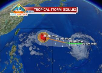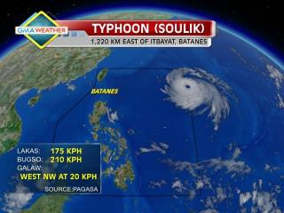
Typhoon Soulik enters PAR, codenamed Huaning. Tropical Storm Soulik, visible as a white circular cloud formation in the upper righthand portion of this image, passed into the Philippine Area of Responsibility at around 10am (PHT) on July 10. It has been given the local codename, Huaning. GMA News The Batanes islands were placed under Storm Signal No. 1 Wednesday afternoon as Typhoon Huaning (Soulik) continued moving toward Northern Luzon, state weather forecasters said. But PAGASA forecaster Jori Loiz said their models indicate Huaning may still not make itself felt until at least Thursday or Friday. “Hindi tatama sa Pilipinas ang bagyong si Huaning,” Loiz said in an interview on dzBB radio. Loiz said their models indicate Huaning may eventually head for Taiwan, though it may enhance the southwest monsoon that will bring rain over parts of the Philippines. The typhoon is still likely to leave the Philippine area of responsibility by early Saturday, he added. “Ang pag-ulan sa habagat maaring Friday afternoon or Saturday,” he said. Advisory In its 5 p.m. advisory, PAGASA said Huaning was estimated at 1,150 km east of Itbayat, Batanes as of 4 p.m. According to PAGASA, Huaning packed maximum winds of 175 kph near the center and gustiness of up to 210 kph, and was moving west-northwest at 20 kph. By Thursday afternoon, it is expected to be 720 km northeast of Itbayat, Batanes. By Friday afternoon it is expected to be 380 km northeast of Itbayat, Batanes. On Saturday afternoon, it is expected to Read More …