Jun 162013
 
PAGASA: TD Emong maintains strength, accelerates slightly

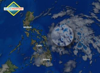
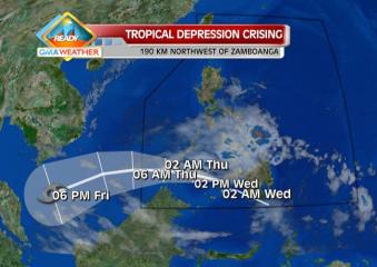
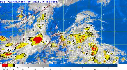
PAGASA: ‘Habagat’, LPA, ITCZ bring rain to various parts of PHL. PAGASA said in its weather bulletin early Sunday morning that the Bicol region, Central and Eastern Visayas and Mindanao will experience cloudy skies with moderate to occasionally heavy rainshowers and thunderstorms which may trigger flash floods and landslides.” PAGASA Tropical Depression Emong accelerated slightly and hovered near Legazpi City in Albay Province on Sunday night, state weather forecasters said. PAGASA, in its 11 p.m. advisory, said Tropical Depression Emong was estimated to be 380 km east of Legazpi City as of 10 p.m. It said Emong packed maximum winds of 45 kph near the center and is forecast to move north-northwest at 13 kph. “Tropical Depression Emong is still far to directly affect any part of the country. However, it will bring moderate to occasionally heavy rains and thunderstorms over southern Luzon, Visayas and Mindanao,” it said. It added Emong “is likely to intensify within the next 24 to 48 hours.” PAGASA said Tropical Depression Emong is expected to be at 360 km northeast of Legazpi City by Monday evening, and 400 km east of Aparri, Cagayan by Tuesday evening. By Wednesday evening, it is forecast to be 530 km northeast of Aparri, Cagayan. Tropical Depression Emong may bring 5 to 15 mm per hour of rainfall (moderate to heavy) within its 300-km diameter, PAGASA said. — DVM, GMA News

Jun 152013
 
PAGASA: LPA hovering off Surigao City; floods, landslides threaten Bicol, Vis-Min

Flash floods and landslides threaten parts of Bicol, Visayas and Mindanao as a low-pressure area hovered off Surigao City Sunday morning, state weather forecasters said. PAGASA said the LPA is embedded along the inter-tropical convergence zone and was estimated at 460 km east of Surigao City as of 4 a.m. “Bicol region, Central and Eastern Visayas and Mindanao will experience cloudy skies with moderate to occasionally heavy rain showers and thunderstorms which may trigger flash floods and landslides,” it said in its 5 a.m. bulletin. It added Palawan and the rest of Visayas will be “cloudy with light to moderate rain showers and thunderstorms.” Metro Manila and the rest of Luzon will have “partly cloudy to cloudy skies with isolated rain showers or thunderstorms,” it said. PAGASA said Metro Manila may expect temperatures of 25 to 34 degrees Celsius, while Tuguegarao City may expect temperatures of 25 to 33 degrees Celsius. Meanwhile, PAGASA said moderate to strong winds from the southwest to southeast will prevail over Central and Southern Luzon and from the east to southeast over Northern Luzon and the coastal waters along these areas will be moderate to rough. Light to moderate winds coming from the north to northwest will prevail over Visayas and from the southwest over Mindanao with slight to moderate seas, it added. Heavy rain falls on Davao City Heavy rain pelted Davao City Saturday night, with the city government’s responder teams placed on alert for possible flooding. In posts on its social networking sites, Read More …

Jun 132013
 
PAGASA: LPA, monsoon may bring floods, landslides in west Luzon, Visayas

Flash floods and landslides threaten parts of Luzon and Visayas Friday due to the southwest monsoon enhanced by a low-pressure area outside the Philippine area of responsibility, state weather forecasters said. PAGASA forecaster Joey Figuracion said Metro Manila, where many were stranded by floods and heavy rain Thursday, may still expect rain showers and thunderstorms for Friday. “Walang weather disturbance na nakaapekto sa ating bansa o Philippine area of responsibility. Pero may low-pressure area sa bahagi ng West Philippine Sea at nag-enhance ng southwest monsoon. Naapektuhan ng southwest monsoon ang kanlurang bahagi ng Luzon at Visayas,” Figuracion said in an interview on dzBB radio. He said the LPA outside the PAR was unlikely to intensify into a cyclone, and may head for China. Friday outlook For Friday, PAGASA said the southwest monsoon is still affecting Luzon and Western Visayas. “The provinces of Palawan, Mindoro, Cavite, Batangas, Zambales and Bataan will experience cloudy skies with moderate to occasionally heavy rain showers and thunderstorms which may trigger flash floods and landslides,” it said in its 5 a.m. bulletin. It added Metro Manila and the rest of the country will be “cloudy with light to moderate rain showers and thunderstorms.” PAGASA also said moderate to strong winds from the southwest to southeast will prevail over Luzon and the coastal waters along these areas will be moderate to rough. Light to moderate winds coming from the southwest to southeast will prevail over Visayas and coming from the northeast to northwest over Mindanao with slight Read More …

Jun 122013
 
PAGASA: Potential cyclone threatens west Luzon, Visayas with floods, landslides

Flash floods and landslides threaten the western parts of Luzon and Visayas Thursday as a  low-pressure area, just outside the Philippine area of responsibility enhances the southwest monsoon, state weather forecasters said. PAGASA forecaster Gener Quitlong said their models show the LPA intensifying into a cyclone. However, it is not likely to enter the Philippine area of responsibility and may instead move toward Vietnam. “Nagpapalakas ito ng habagat,” Quitlong said in an interview on dzBB radio. But if the LPA intensifies into a cyclone and enters the Philippine Area of Responsibility, it will be codenamed Emong, he said. Thursday outlook For Thursday, PAGASA said the southwest monsoon is affecting the western sections of Luzon and Visayas. “Calabarzon, Mimaropa, Western Visayas and the provinces of Zambales and Bataan will experience cloudy skies with moderate to occasionally heavy rain showers and thunderstorms which may trigger flash floods and landslides,” it said in its 5 a.m. bulletin. It added Zamboanga Peninsula, Northern Mindanao and the rest of Luzon and of Visayas will be cloudy with light to moderate rain showers and thunderstorms. The rest of Mindanao will have partly cloudy skies with isolated rain showers or thunderstorms, it added. Also, moderate to strong winds from the southwest to south will prevail over the western sections of Luzon and Visayas and the coastal waters along these areas will be moderate to rough. Light to moderate winds coming from the southeast to south will prevail over the rest of Luzon and Visayas and from the Read More …

Jun 072013
 
Coast Guard urges residents in coastal areas to take precautions vs. floods

The Philippine Coast Guard (PCG) on Friday advised residents in coastal areas, especially in Visayas and Mindanao, to take precautions against floods and landslides that may be caused by a potential cyclone. Coast Guard spokesman Lt. Cmdr. Armand Balilo said residents should keep alert for heavy rain and be ready to evacuate if needed, radio dzBB’s Carlo Mateo reported. Balilo also advised residents to keep handy in the house various emergency items such as food, water and flashlights as well as batteries. He said an average of 21 to 23 cyclones enter the Philippine area of responsibility every year. Earlier on Friday, PAGASA said flash floods and landslides may threaten parts of Visayas and Mindanao as a potential cyclone, a low-pressure area, moved close to Eastern Samar. PAGASA forecaster Elvie Enriquez said the LPA was near Samar and had a “50-50 chance” of intensifying into a cyclone. If the LPA intensifies into a cyclone while inside the Philippine area of responsibility, it will be locally codenamed Dante. – VVP, GMA News

Jun 072013
 
Flood, landslide warnings still up in VisMin, Palawan as LPA nears

Satellite Image at 7 a.m., June 6, 2013. | Weather Central A potential cyclone off Catanduanes province threatens to bring rain that can trigger flash floods and landslides in parts of Palawan, Western Visayas and Mindanao, state weather forecasters said Friday afternoon. PAGASA said the low-pressure area (LPA) was estimated at 590 km northeast of Virac, Catanduanes as of 4 p.m., embedded in the inter-tropical convergence zone (ITCZ) affecting Bicol, Visayas and Mindanao. “Mindanao, Western Visayas and Palawan will experience cloudy skies with moderate to occasionally heavy rains and thunderstorms which may trigger flash floods and landslides,” it said in its 5 p.m. bulletin. It added Bicol and the rest of Visayas will have “cloudy skies with light to moderate rain showers and thunderstorms.” On the other hand, Metro Manila and the rest of Luzon will be “partly cloudy with isolated rain showers or thunderstorms mostly in the afternoon or evening,” PAGASA said. Earlier, PAGASA forecaster Elvie Enriquez said the LPA has a 50-50 chance of intensifying into a cyclone. Should it intensify into a cyclone while inside the Philippine area of responsibility, it will be codenamed Dante. For Saturday, Metro Manila, Angeles and Olongapo Cities may expect temperatures of 25 to 34 degrees Celsius, while Tuguegarao City may expect temperatures of 25 to 36 degrees Celsius. Meanwhile, PAGASA said moderate to occasionally strong winds from the northwest to west will prevail over Eastern Luzon and coming from the southwest over Palawan and the western section of Visayas and Mindanao. Read More …

Jun 072013
 
Heavy rain in Mindanao from LPA; at least 2 flights cancelled

Satellite Image at 7 a.m., June 6, 2013. | Weather Central At least two flights between Manila and Mindanao were canceled Friday afternoon due to bad weather, the Department of Transportation and Communications said. The DOTC said on its Twitter account the affected flights were those of Cebu Pacific, between Manila and Cagayan de Oro City. It said these included 5J-389 from Manila to Cagayan de Oro, and 5J-390 from Cagayan de Oro to Manila. As this developed, state weather forecasters warned of heavy rain in several parts of Mindanao, due to a potential cyclone. In a post on its Facebook page, PAGASA warned of heavy rain over Zamboanga del Norte, Misamis Occidental, Lanao del Norte, Davao del Norte, Misamis Oriental and portions of North Cotabato, Maguindanao, Agusan del Norte and Agusan del Sur. “Flooding is threatening in low-lying areas,” it said. PAGASA, in its 5 p.m. bulletin, also said a potential cyclone – a low-pressure area – may trigger flash floods and landslides in parts of Palawan, Western Visayas and Mindanao in the next 24 hours. “Mindanao, Western Visayas and Palawan will experience cloudy skies with moderate to occasionally heavy rains and thunderstorms which may trigger flash floods and landslides,” it said. — TJD, GMA News

Jun 062013
 
PAGASA: Potential cyclone nears Samar; floods, landslides threaten Vis-Min

Satellite Image at 7 a.m., June 6, 2013. | Weather Central Flash floods and landslides threaten parts of the Visayas and Mindanao as a potential cyclone or low-pressure area (LPA) moved closer to Eastern Samar early Friday, state weather forecasters said. PAGASA forecaster Elvie Enriquez said the LPA was estimated at 460 km east of Borongan City, Eastern Samar as of 4 a.m. “Ito bigyan natin ng 50-50 chance maging bagyong tropikal… Malapit na ito sa land mass,” she said in an interview on dzBB radio. She said the LPA is bringing rain to Eastern Samar, though it is not heavy as yet. Enriquez also said the LPA may cause the southwest monsoon to affect the country and start the rainy season. “[Pero] wala pa ang onset [ng rainy season], hindi pa,” she said. Should the LPA intensify into a cyclone while inside the Philippine area of responsibility, it will be locally codenamed Dante. Friday outlook PAGASA’s 5 a.m. bulletin said the LPA is embedded along the inter-tropical convergence zone affecting Bicol, Visayas and Mindanao. “Eastern Visayas, northern Mindanao and Zamboanga Peninsula will experience cloudy skies with moderate to occasionally heavy rains and thunderstorms which may trigger flash floods and landslides,” it said. It added Calabarzon, Mimaropa, Bicol region and the rest of Visayas and of Mindanao will have “cloudy skies with light to moderate rainshowers and thunderstorms.” Metro Manila and the rest of Luzon will be “partly cloudy to cloudy with isolated rainshowers or thunderstorms mostly in the afternoon Read More …

Jun 062013
 
Flashflood, landslide warnings up in Mindanao as potential cyclone nears PHL

Satellite Image at 7 a.m., June 6, 2013. | Weather Central A potential cyclone is now inside the Philippine area of responsibility and may head towards Mindanao, state weather forecasters said Thursday. PAGASA forecaster Alvin Pura said the LPA formed inside the Philippine area of responsibility (PAR) Thursday morning and is embedded within the inter-tropical convergence zone (ITCZ). “‘Yung inaasahang LPA nabuo na. Nariyan nakapaloob sa ITCZ … sa loob na ito (ng PAR),” Pura said in an interview on dzBB radio. But he said there is still no storm signal raised yet, as PAGASA is still monitoring the LPA to see whether or not it will intensify into a cyclone.  Should it become a cyclone, it will be locally codenamed Dante. Meanwhile, PAGASA forecaster Joey Figuracion said that there is also a chance that the disturbance may veer north towards Taiwan.  “Kung napunta sa area ng Pacific papuntang Japan, pwede maging ganap na bagyo,” Pura said. Flashflood, landslide warnings up in Mindanao PAGASA’s 11 a.m. advisory said the LPA and the ITCZ may trigger flash floods and landslides in Mindanao. It said that, as of 8 a.m., the LPA was estimated at 580 km east of Hinatuan, Surigao Del Sur, embedded in the ITCZ. “These weather systems will affect the Bicol region, Visayas and Mindanao,” it said, adding the whole Mindanao “will experience cloudy skies with moderate to heavy rains and thunderstorms which may trigger flash floods and landslides.” “Residents in these areas are advised to take all the Read More …

Feb 192013
 
TD Crising slows down, but storm signals still hoisted

Predicted track for TD Crising as of 20Feb2013. TD Crising is expected to leave the Philippine Area of Responsibility by early morning tomorrow, Thursday, 21Feb2013. Weather Central Tropical Depression (TD) Crising slowed down as it crossed the Sulu Sea before noon Wednesday, even as two areas were placed under Storm Signal No. 1, state weather forecasters said. PAGASA, in its 11 a.m. advisory, said Tropical Depression Crising was estimated at 220 km northwest of Zamboanga City as of 10 a.m. It said Crising packed maximum winds of 45 kph near the center and is moving west-northwest at 19 kph. By Thursday morning, PAGASA said Crising is expected to be 280 km southwest of Puerto Princesa City. By Thursday evening, it estimated Crising to be 480 km southwest of Puerto Princesa City. Under Storm Signal No. 1 are Southern Palawan and Zamboanga del Norte. Storm warning signals in other areas had been lowered, PAGASA said. It said Crising may bring rainfall of 5 to 15 mm per hour (moderate to heavy) within its 300-km diameter. “Residents living in low-lying and mountainous areas under Storm Signal No. 1 are alerted against possible flash floods and landslides,” PAGASA said.  PAGASA also reminded fishing boats and other small seacraft against going out into the northern, eastern and southern seaboards of Luzon, the central and eastern seaboards of Visayas and eastern seaboard of Mindanao. LPA off Puerto Princesa  Meanwhile, PAGASA said a low-pressure area northwest of Puerto Princesa City has dissipated. — TJD, GMA News