Jul 112013
 
PAGASA: Huaning weakens slightly, continues moving toward Batanes-Taiwan area

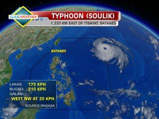
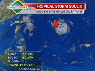
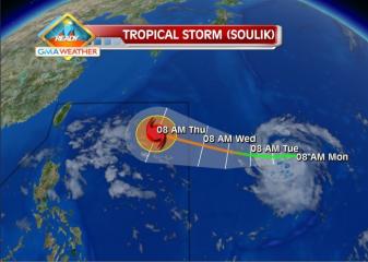
Typhoon Huaning (international name Soulik) weakened slightly even as it continued moving toward the Taiwan-Batanes area Thursday night, state weather forecasters said. PAGASA, in its 11 p.m. advisory, said Huaning was estimated to be 580 km east-northeast of Itbayat, Batanes as of 10 p.m. Huaning packed maximum winds of 175 kph near the center and gustiness of up to 210 kph, and was moving west-northwest at 20 kph. Batanes remained under Storm Signal No. 1. PAGASA projects Huaning may be 370 km north-northeast of Itbayat, Batanes by Friday evening, and 640 km north-northwest of Itbayat, Batanes or outside the Philippine Area of Responsibility by Saturday evening. Meanwhile, PAGASA said Huaning may still bring rainfall of 10 to 46 mm per hour (heavy to torrential) within its 900-km diameter. It warned fishermen, especially those using small seacraft, not to venture out into the northern and eastern seaboards of Luzon due to big waves generated by Huaning. — DVM, GMA News

Jul 112013
 
PAGASA: Typhoon Huaning moving toward Batanes-Taiwan area

Typhoon Soulik enters PAR, codenamed Huaning. Tropical Storm Soulik, visible as a white circular cloud formation in the upper righthand portion of this image, passed into the Philippine Area of Responsibility at around 10am (PHT) on July 10. It has been given the local codename, Huaning. GMA News Typhoon Huaning (Soulik) maintained its strength as it moved toward the Batanes-Taiwan area Thursday afternoon, state weather forecasters said. PAGASA forecaster Aldczar Aurelio said Huaning is not likely to make landfall over the Philippines so long as it does not change its present course. “Hindi sya magla-landfall basta ma-maintain ang course,” Aurelio said in an interview on dzBB radio. But he said Huaning has a diameter of 900 km and may bring heavy rain to parts of Batanes, which is under Storm Signal No. 1. PAGASA’s 5 p.m. advisory said Huaning has maintained its strength as it moves in the general direction towards the Taiwan-Batanes area. As of 4 p.m., it was estimated at 690 km east-northeast of Itbayat, Batanes. Huaning packed maximum winds of 185 kph near the center and gustiness of up to 220 kph, and was moving west-northwest at 20 kph. By Friday afternoon, it is expected to be 410 km northeast of Itbayat, Batanes. By Saturday afternoon it is expected to be 540 km north-northwest of Itbayat, Batanes and outside the Philippine Area of Responsibility. PAGASA said Huaning may bring rainfall of 10 to 46 mm per hour (heavy to torrential) within its 900-km diameter. “Fishermen specially those Read More …

Jul 102013
 
PAGASA: Typhoon Huaning still heading for north Luzon, may become super typhoon

Typhoon Huaning (Soulik) moved closer to Batanes in extreme northern Luzon early Thursday, while state weather forecasters were not discounting the possibility that it could further intensify into a supertyphoon. “Hindi pa siya umaabot pero nariyan posibilidad na maging supertyphoon kasi nasa karagatan pa siya,” PAGASA forecaster Buddy Javier said in an interview on dzBB radio. Javier said a cyclone must have maximum sustained winds of 210 kph and gustiness of 250 kph to be considered a supertyphoon. But Javier said Huaning was moving west-northwest and was unlikely to make landfall over the Philippines. “Pinapakita ng model natin maliit chance tumama sa kalupaan ng ating bansa. Tinatahak niya papunta northern Taiwan gigilid lang pero maapektuhan ilang part ng Batanes,” he said. As of Thursday morning, he said Huaning had maximum sustained winds of 175 kph near the center and gustiness of up to 210 kph. 5 a.m. advisory PAGASA’s 5 a.m. advisory said Huaning was estimated at 910 km east of Itbayat, Batanes as of 4 a.m. It said Huaning was moving west-northwest at 20 kph and is expected to be 550 km northeast of Itbayat, Batanes Friday morning. By Saturday morning, it is expected to be 420 km north of Itbayat, Batanes. By Sunday morning it is expected to be 710 km northwest of Itbayat, Batanes or outside the Philippine area of responsibility. Batanes remained under Storm Signal No. 1. PAGASA said Huaning may bring rainfall of 10 to 25 mm per hour (heavy to intense) within its 800-km Read More …

Jul 102013
 
PAGASA: Huaning maintains strength, west-northwest course

TS Soulik as of 5pm, 9July2013. As of Tuesday afternoon, tropical storm Soulik was located some 1,570km east of Basco, Batanes. It is expected to enter the Philippine Area of Responsibility by Wednesday morning, and will be locally codenamed Huaning. GMA News Typhoon Huaning (Soulik) maintained its strength as it continued to move west-northwest Wednesday night, state weather forecasters said. PAGASA, in its 11 p.m. advisory, said Batanes in extreme northern Luzon remained under Storm Signal No. 1. As of 10 p.m., PAGASA said Huaning was estimated to be 1,030 km east of Itbayat, Batanes, with maximum winds of 175 kph near the center and gustiness of up to 210 kph. It was moving west-northwest at 20 kph and would be 640 km northeast of Itbayat, Batanes Thursday evening. By Friday evening, it is expected to be 390 km north-northeast of Itbayat, Batanes. By Saturday evening it is forecast to be 600 km north-northwest of Itbayat, Batanes or outside the Philippine Area of Responsibility. PAGASA said Huaning may bring rainfall of 10 to 25 mm per hour (heavy to intense) within its 800-km diameter. PAGASA warned fishermen, especially those using small seacraft, not to venture to the northern and eastern seaboards of Luzon due to big waves generated by Huaning. — DVM, GMA News

Jul 102013
 
PAGASA: Signal 1 over Batanes; Huaning effects expected starting Thursday

Typhoon Soulik enters PAR, codenamed Huaning. Tropical Storm Soulik, visible as a white circular cloud formation in the upper righthand portion of this image, passed into the Philippine Area of Responsibility at around 10am (PHT) on July 10. It has been given the local codename, Huaning. GMA News The Batanes islands were placed under Storm Signal No. 1 Wednesday afternoon as Typhoon Huaning (Soulik) continued moving toward Northern Luzon, state weather forecasters said. But PAGASA forecaster Jori Loiz said their models indicate Huaning may still not make itself felt until at least Thursday or Friday. “Hindi tatama sa Pilipinas ang bagyong si Huaning,” Loiz said in an interview on dzBB radio. Loiz said their models indicate Huaning may eventually head for Taiwan, though it may enhance the southwest monsoon that will bring rain over parts of the Philippines. The typhoon is still likely to leave the Philippine area of responsibility by early Saturday, he added. “Ang pag-ulan sa habagat maaring Friday afternoon or Saturday,” he said. Advisory In its 5 p.m. advisory, PAGASA said Huaning was estimated at 1,150 km east of Itbayat, Batanes as of 4 p.m. According to PAGASA, Huaning packed maximum winds of 175 kph near the center and gustiness of up to 210 kph, and was moving west-northwest at 20 kph. By Thursday afternoon, it is expected to be 720 km northeast of Itbayat, Batanes. By Friday afternoon it is expected to be 380 km northeast of Itbayat, Batanes. On Saturday afternoon, it is expected to Read More …

Jul 092013
 
PAGASA: Typhoon Soulik may enter PAR before noon, landfall not discounted

Tropical Storm Soulik forecast track as of 8Jul2013. The Weather Central forecast track for Soulik as of 8am Monday shows that the tropical storm may enter the northeastern corner of the Philippine Area of Responsibility by Wednesday. GMA News Typhoon Soulik intensified further as it moved closer toward Batanes in extreme northern Luzon, and may enter the Philippine area of responsibility before noon Wednesday, state weather forecasters said. PAGASA forecaster Samuel Duran also said Soulik, to be codenamed Huaning once it is inside the PAR, also slightly changed course and is now moving west-northwest. “Babantayan natin kung sakali, baka sumubsob [sa kalupaan] dahil may lumalakas na high-pressure area na nakatuntong sa kanya kaya nahirapan siya mag-northward,” Duran said in an interview on dzBB radio. He said their models indicate the possibility of Soulik – now with an 800 km diameter – making landfall over the Batanes area in extreme northern Luzon. Duran said their models also indicate Soulik may enter the Philippine area of responsibility between 10 and 11 a.m. While he said Soulik is not likely to affect Metro Manila, it may make itself felt by enhancing the southwest monsoon. “Expect natin kung magtuloy-tuloy si Soulik, by tomorrow afternoon maranasan natin ang pag-ulan,” he said. He added Soulik is expected to leave the Philippine area of responsibility by early Saturday. As of 4 a.m., PAGASA said Soulik was estimated at 1,365 km east of Itbayat, Batanes, with maximum sustained winds of 150 kph near the center and gustiness of Read More …

Jul 082013
 
PAGASA: TS Soulik intensifies further, may stay in PHL until Friday

Cyclone off of PAR as of 5am, July 8. The Japan Meteorological Agency’s forecast track of a cyclone just outside the Philippine Area of Responsibility (PAR) as of 5am (PHT), July 8. At its current rate and direction, PAGASA says it may enter the PAR by Wednesday and may just bring to extreme Northern Luzon. Japan Meteorological Agency Tropical Storm Soulik intensified further early Tuesday as it continued to approach the Philippines, even as state weather forecasters said the cyclone may enter the Philippine area of responsibility Wednesday and stay until Friday. But PAGASA forecaster Manny Mendoza said their models show Soulik is not likely to make landfall on any part of the Philippines, even as it will enhance the southwest monsoon. “Hindi ito magla-landfall sa Pilipinas. Kung papatuloy ito, maaring mag-landfall ito sa Taiwan. Kung west-northwest or northwest ito, sa southeastern China (Our models show it is not likely to make landfall on the Philippines. Our models show it could make landfall on Taiwan. Or if it goes west-northwest or northwest, it could make landfall on Southeastern China),” Mendoza said in an interview on dzBB radio. Also, he said their models show a possibility of Soulik heading for Korea or even Japan. The Japan Meteorological Agency’s 5:45 a.m. update described Soulik as a strong tropical storm, and indicated Soulik may not make landfall over the Philippines. So far, Mendoza said their forecast models indicate Soulik is not likely to have any direct effect on the Philippines, but added it Read More …

Jul 082013
 
PAGASA: Storm Soulik intensifies, moves closer to PHL 

Tropical Storm Soulik forecast track as of 8Jul2013. The Weather Central forecast track for Soulik as of 8am Monday shows that the tropical storm may enter the northeastern corner of the Philippine Area of Responsibility by Wednesday. GMA News Tropical Storm Soulik intensified anew Monday afternoon as it moved closer to the Philippine Area of Responsibility, state weather forecasters said. In a radio interview, PAGASA forecaster Gladys Saludes said Soulik is  expected to enter the PAR Wednesday afternoon. “Bahagya ito lumakas… by Wednesday afternoon papasok ito ng Philippine Aea of Responsibility,” Saludes told dzBB radio. Once it does, she said the tropical storm will be locally codenamed Huaning. She said the storm is expected to enhance the southwest monsoon. Saludes said that as of 5 p.m., Soulik was estimated at 2,010 km east of Basco, Batanes, packing maximum sustained winds of 85 kph and gustiness of up to 100 kph. It is moving west at 20 kph, she added. “Maghahatak ito ng habagat sa Huwebes,” she said. The Japan Meteorological Agency, meanwhile, projected that Soulik may continue to move west. Tuesday outlook PAGASA’s 5 p.m. bulletin said the Intertropical Convergence Zone will continue to affect Palawan and Mindanao. “Light to moderate winds blowing from the east to southeast will prevail over Luzon and coming from the east to northeast over Visayas and Mindanao. The coastal waters throughout the archipelago will be slight to moderate,” it said. — RSJ, GMA News

Jul 062013
 
PAGASA: Cloudy skies, rainy weather over much of PHL Sunday

Cloudy skies and rainy weather may prevail over several parts of the country in the next 24 hours due to the Inter-tropical Convergence Zone, state weather forecasters said Saturday afternoon. PAGASA, in its 5 p.m. bulletin, said the ITCZ is affecting mainly Palawan and Mindanao, even as parts of Southern Luzon, Bicol, Visayas and Mindanao may expect rain. “Mimaropa, Bicol region, Eastern Visayas and Mindanao will experience cloudy skies with light to moderate rain showers and thunderstorms,” it said. It added Metro Manila and the rest of the country will be “partly cloudy to cloudy with isolated rain showers or thunderstorms.” PAGASA also said light to moderate winds from the east to southeast will prevail over Luzon and Visayas and coming from the east over Mindanao. The coastal waters throughout the archipelago will be slight to moderate, it added. Earlier, PAGASA forecasters said they do not expect any low-pressure area or cyclone this weekend, though the ITCZ may bring rain. — LBG, GMA News

Jul 062013
 
PAGASA: Thunderstorm affecting parts of Metro Manila, Bulacan

Residents of Metro Manila and Bulacan may have to take precautions against flash floods due to rain from a thunderstorm, state weather forecasters said on Saturday afternoon. In a 1:00 p.m. thunderstorm advisory, PAGASA said rain may fall over the Camanava (Caloocan, Malabon, Valenzuela, Navotas) area of Metro Manila. PAGASA also said the thunderstorm may affect Santa Maria and Balagtas in Bulacan and nearby areas in the next two hours. “All are advised to take precautionary measures against heavy rains, strong winds, lightning and possible flash floods. Keep monitoring for updates,” it advised. PAGASA earlier said the Inter-Tropical Convergence Zone affecting parts of Southern Luzon, Visayas and Mindanao may bring rain to most parts of the country. This was noted despite their models showing there is little chance of a cyclone forming in the Philippine Area of Responsibility this weekend, PAGASA said. – VVP, GMA News